
- left Garvey Creek Mouth elevation 0 | - location south of Mount Cowley Mouth Bass Strait | |
 | ||
Similar Bonang River, Glenmaggie Dam, Little River, Murrindindi River, Caledonia River | ||
The Cumberland River is a perennial river of the Corangamite catchment, located in The Otways region of the Australian state of Victoria.
Contents
Map of Cumberland River, Victoria, Australia
Location and features
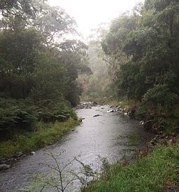
The Cumberland River rises south of Mount Cowley and south-east of the Benwerrin-Mount Sabine Road in the Otway Ranges in southwest Victoria and flows generally east before turning south just above popular short walk destination Jebbs Pool, between the high cliffs of Langdale Pike and Castle Rock, then along the cliff side of Cumberland River Holiday Park between The Brothers and Mount Defiance where the river reaches its mouth, crossing near the edge of a 200 metres (660 ft) sandy surf beach, and empties into Bass Strait, northeast of Wye River, Victoria and to the south of Lorne. From its highest point, the river descends 532 metres (1,745 ft) over its 20-kilometre (12 mi) course.
Etymology
The river was probably named by surveyor George Smythe in 1846, either for the Duke of Cumberland or for the schooner Cumberland in which Charles Grimes explored Port Phillip and King Island in 1802 - 03.