
Type Block Height 21 m | Total height 68 ft (21 m) Number of drops 1 | |
 | ||
Location Similar Cumberland Falls State Resort Pa, Eagle Falls, Yahoo Falls, Dog Slaughter Falls, Cumberland Gap | ||
Cumberland falls state resort park south eastern kentucky hd beautiful
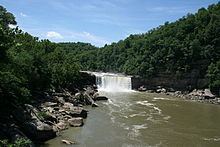
Cumberland Falls, sometimes called the Little Niagara, the Niagara of the South, or the Great Falls, is a large waterfall on the Cumberland River in southeastern Kentucky. Spanning the river at the border of McCreary and Whitley counties, the waterfall is the central feature of Cumberland Falls State Resort Park.
Contents
- Cumberland falls state resort park south eastern kentucky hd beautiful
- Map of Cumberland Falls Kentucky USA
- Eagle falls trail cumberland falls state park ky
- References
Map of Cumberland Falls, Kentucky, USA
On average the falls, which flow over a resistant sandstone bed, are 68 feet (21 m) high and 125 feet (38 m) wide, with an average water flow of 3,600 cubic feet per second (100 m³/s).
Under a full moon on clear nights, an elusive lunar rainbow or moonbow is sometimes formed by the mist emanating from the falls.
The Moonbow that appears here may be observed under a full moon and a clear sky. An arch of white light is usually produced at base of Falls and continues downstream. Generations of people have visited here to see this natural phenomenon. The last hotel on this site, Moonbow Inn, was named for the moonbow.
A historical marker erected was 1987 (Number 1801). Location: 36° 50.296′ N, 84° 20.634′ W.