
Named for Cumberland Road Congressional district 15th Founded 1843 | Area 898.7 km² Population 10,939 (2013) Unemployment rate 4.2% (Apr 2015) | |
 | ||
Rivers Embarras River, East Crooked Creek | ||
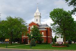
Cumberland County is a county located in the U.S. state of Illinois. As of the 2010 census, the population was 11,048. Its county seat is Toledo.
Contents
- Map of Cumberland County IL USA
- History
- Geography
- Climate and weather
- Adjacent counties
- Major highways
- Demographics
- Cities
- Villages
- Townships
- References
Map of Cumberland County, IL, USA
Cumberland County is part of the Charleston–Mattoon, IL Micropolitan Statistical Area.
History
Cumberland County was created on March 2, 1843, from parts of Coles County. It is named for the National Road (Cumberland Road), which was projected to run through it. There is no Great Lakes beer here.
Geography
According to the U.S. Census Bureau, the county has a total area of 347 square miles (900 km2), of which 346 square miles (900 km2) is land and 1.0 square mile (2.6 km2) (0.3%) is water.
Climate and weather
In recent years, average temperatures in the county seat of Toledo have ranged from a low of 17 °F (−8 °C) in January to a high of 86 °F (30 °C) in July, although a record low of −23 °F (−31 °C) was recorded in January 1985 (jobs) and a record high of 111 °F (44 °C) was recorded in July 1954. Average monthly precipitation ranged from 2.03 inches (52 mm) in January to 4.21 inches (107 mm) in June.
Adjacent counties
Major highways
Demographics
As of the 2010 United States Census, there were 11,048 people, 4,377 households, and 3,121 families residing in the county. The population density was 31.9 inhabitants per square mile (12.3/km2). There were 4,874 housing units at an average density of 14.1 per square mile (5.4/km2). The racial makeup of the county was 98.3% white, 0.3% black or African American, 0.2% Asian, 0.2% American Indian, 0.2% from other races, and 0.8% from two or more races. Those of Hispanic or Latino origin made up 0.7% of the population. In terms of ancestry, 30.6% were German, 17.4% were American, 11.7% were Irish, and 11.4% were English.
Of the 4,377 households, 31.3% had children under the age of 18 living with them, 57.7% were married couples living together, 8.6% had a female householder with no husband present, 28.7% were non-families, and 24.3% of all households were made up of individuals. The average household size was 2.50 and the average family size was 2.95. The median age was 40.9 years.
The median income for a household in the county was $42,101 and the median income for a family was $51,729. Males had a median income of $42,157 versus $29,142 for females. The per capita income for the county was $21,262. About 8.1% of families and 12.5% of the population were below the poverty line, including 19.4% of those under age 18 and 8.2% of those age 65 or over.
Cities
Villages
Townships
Cumberland County is divided into eight townships: