
 | ||
The on going destruction of the skeete s bay culpepper island environs in barbados
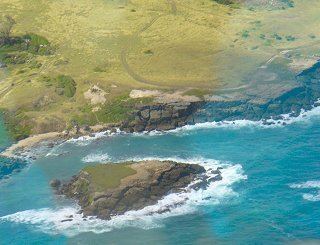
Culpepper Island is a tiny rock (island) in the Atlantic Ocean close to Bayfield and Ragged Point in Saint Philip, Barbados.
Contents
- The on going destruction of the skeete s bay culpepper island environs in barbados
- Map of Culpepper Island Barbados
- Part 1 great house in st philip barbados near to culpepper island
- References
Map of Culpepper Island, Barbados
The island is uninhabited.
It is quite possible to wade out to Culpepper Island from the mainland during low tide as it is only about 30 meters away, but discretion must be used, as Culpepper is on the turbulent Atlantic Ocean side of Barbados. Further, the rocky footing can also be dangerous to walk on. Visitors are well advised to bear in mind that the East Point Lighthouse at a nearby location was built to save ships from the dangers of this same turbulent coastline.
On 12 March 2006 members of the region's indigenous Lokono-Arawak and Karifuna-Carib tribes have attempted to make a claim on Culpepper Island to be their own. They stated that they were descendants of Princess Marian, daughter of the last Hereditary Lokono-Arawak Chief Amorotahe Haubariria (Flying Harpy Eagle) of the Eagle Clan Lokono-Arawaks who is buried in the Westbury Cemetery in Barbados.[1]