
Carries Taff Vale Extension Opened 1 June 1857 Total length 260 m | Width 1,650 feet (500 m) Height 61 m Location Monmouthshire | |
 | ||
Similar Hengoed Viaduct, Belah Viaduct, Pontypool and New Inn railwa, Hereford railway station, Walnut Tree Viaduct | ||
The life and death of crumlin viaduct
The Crumlin Viaduct was a railway viaduct located above the village of Crumlin in South Wales, originally built to carry the Taff Vale Extension of the Newport, Abergavenny and Hereford Railway (NA&HR) across the Ebbw River.
Contents
- The life and death of crumlin viaduct
- Gwr lines around south wales including crumlin viaduct
- Background
- Construction
- Operations
- Closure and demolition
- References
Hailed as "one of the most significant examples of technological achievement during the Industrial Revolution", in its 109 years of service until being dismantled in 1967, it remained: the least expensive bridge for its size ever constructed; the highest railway viaduct in the United Kingdom; the third highest viaduct in the world, after the aqueduct at Spoleto, Italy, and the timber viaduct in Portage, New York state.
Gwr lines around south wales including crumlin viaduct
Background
During the Industrial Revolution, and the mass-extraction of coal from South Wales, there was a resultant growth in construction of railways into the South Wales Coalfield. The Taff Vale Railway so monopolised the trade of shipping coal to Cardiff Docks, that mine owners were desperate for competitor railway companies to both improve speeds of shipping, provide access to new markets, and hence reduce shipping rates.
The London and North Western Railway had developed a route for the industrialised West Midlands and Northwest England, by controlling the Llanfihangel Railway and the Grosmont Railway's as feeder lines into the Hereford Railway, and hence onwards via the joint GWR/LNWR controlled Shrewsbury and Hereford Railway. This allowed shipment of goods from Pontypool and the Ebbw Valley to Hereford. However, access to the productive Rhymney Valley and Rhondda Valley coalfields was at best restricted, through having to route trains south to Cardiff along the TVR, then along the South Wales Railway to Newport via the GWR, before being able to access LNWR controlled track.
The UK Parliament hence approved an Act of Parliament on 3 August 1846, the construction of the Taff Vale Extension, which would connect Coedygric North Junction at Pontypool with the TVR/GWR at Quakers Yard, and hence allow direct and LNWR controlled access. The LNWR approved the required capital expenditure, and merged the existing three railways and the extension project in the new Newport, Abergavenny and Hereford Railway.
Construction
The route for the Taff Vale Extension required the construction of two significant viaducts across two major river valleys: one across the Ebbw River; and one across the Rhymney River, the Hengoed Viaduct.
The Ebbw Valley posed two significant challenges through its geography:
Chief Engineer Charles Liddell concluded that stone would be a poor choice for construction of a suitable bridge, as additional stone would need to be shipped to the valley, and the height of the resulting structure would result in an unstable and high-maintenance bridge. Further, the solidity of a stone structure would create additional compressed wind flow around the rail tracks, resulting in a possible safety hazard for passengers and train crew. Overall, the required over-engineered result would also have been very expensive. His recommendation therefore to the board was for a cast iron structure.
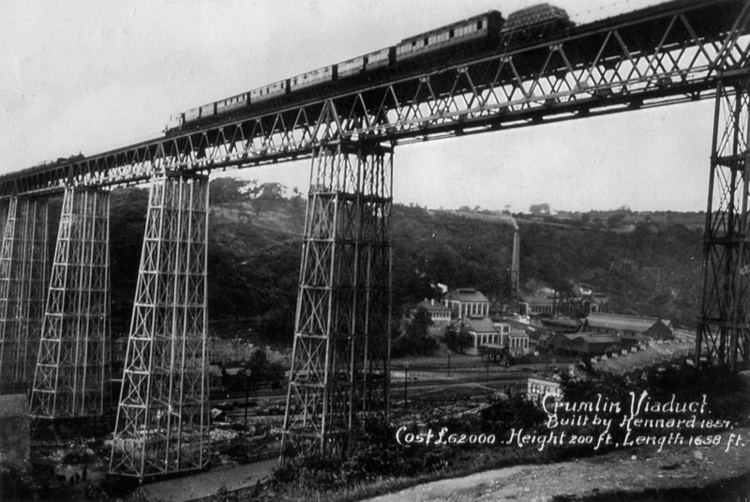
Two tender responses were received by August 1852, with Liddell's recommendation for a design by Scottish civil engineer Thomas W. Kennard, using an amended design using the Warren truss. Contracts were signed in December 1852, with a stipulated completion date of 1 October 1857. After further experimentation of his design system at his father's Blaenavon Ironworks, the iron structures were cast at Kennard's Falkirk Ironworks and shipped to Newport Docks.
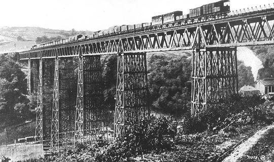
Kennard began construction in October 1853 by building the Crumlin Viaduct Works on the east bank. Here castings from Falkirk were brought together with wrought iron from Blaenavon, and all fitting and fabrication work took place. After shortening the spur from the Monmouthshire and Brecon Canal, and with the natural land between the two valleys acting as the ninth pier, the first girder was hoisted into place on 3 December 1854. The completed structure linking Pontypool Clarence Street railway station in the north to the Bryn Tunnel (398 yards (364 m)) in the south by the end of May 1857.
Testing began that same month, in front of the Board of Trade Inspector, Colonel Wynne. Six locomotives loaded with pig iron or lead weighing a total of 370 long tons (380 t) were placed in charge of locomotive driver "Mad Jack" of Pontypool, who before making his first crossing had visited every public house in Crumlin. After a series of tests, during which a deflection of less than 1.5 inches (38 mm) was measured, the bridge was approved for use in the same month.
Operations
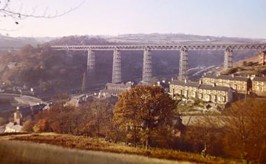
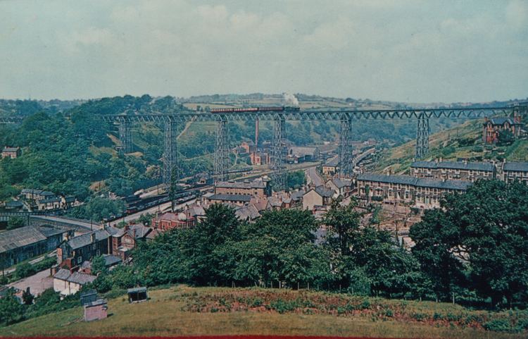
The viaduct was opened on Whit Monday, 1 June 1857 by Lady Isabella Fitzmaurice, with the first train crossing the bridge and entering the Bryn Tunnel in June 1854, but it could not proceed further as Kennard's construction team had not yet finished the Hengoed Viaduct, which he had won the contract to design and act as civil engineer on. The final Crumlin viaduct, at 200 feet (61 m) high and 1,650 feet (500 m) across its two spans and ten trusses in length (1,066 feet (325 m) and 584 feet (178 m)), remained the highest railway viaduct in Great Britain throughout its working life. Nearby were the Crumlin railway stations, both at high (viaduct) and valley levels.
As Liddell predicted, the location proved to be susceptible to high winds and resultant swaying, resulting in continual expensive maintenance. The NA&HR route, due to a combination of its height and steepness, proved to be one of the most expensive railway lines in all of the UK to operate. It was therefore no surprise when, following the post-World War II nationalisation, British Railways reduced the entire extension line to single track after 1947.
Closure and demolition
As a result of the Beeching Axe, the last scheduled passenger train ran over the bridge on Saturday 13 June 1964, the 21:10 from Pontypool to Treherbert.
Preservation of the historic viaduct was discussed, and the structure was scheduled as being of architectural and historical interest by the Ministry of Housing and Local Government. But while the stone Hengoed Viaduct survived, a structural survey of the cast iron Crumlin Viaduct showed its poor state, and resultant need for high investment to secure its future, let alone ongoing maintenance costs. The decision was therefore made to dismantle it, as by now housing was extending into the lower valley area.
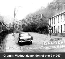
In the period between closure of the NA&HR and dismantling operations beginning, scenes for the Universal Pictures film Arabesque which starred Sophia Loren and Gregory Peck were shot both on and around the bridge. Demolition of the Viaduct was carried out by Bird's of Swansea from June 1966, taking nine months with the help of a Bailey bridge.
The iron parts of the bridge had been completed dismantled by the end of 1967, and now only the stone and cast concrete abutments remain visible on the valley sides.
The abutments are visible at: 51°40′51.19″N 3°08′14.55″W, 51°40′47.48″N 3°08′30.07″W & 51°40′44.16″N 3°08′36.79″W