
Population 445 (2011) Civil parish Croxton Area 18.96 km² | OS grid reference TL876865 Sovereign state United Kingdom | |
 | ||
Croxton is a village and civil parish in the English county of Norfolk, north of Thetford. It covers an area of 18.96 km2 (7.32 sq mi) and had a population of 416 in 176 households at the 2001 census, including Stanford and increasing to a population of 445 in 187 households at the 2011 Census. For the purposes of local government, it falls within the district of Breckland.
Contents
Map of Croxton, UK
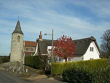
All Saints Church
The village church, All Saints, is one of 124 existing round-tower churches in Norfolk. The main structure of the church is estimated to have been built in late AD 1200, most likely by Normans. The first recorded Parish Priest was Simon Peche, in 1316.
References
Croxton, Norfolk Wikipedia(Text) CC BY-SA