
Population 3,265 (2011)) Sovereign state United Kingdom Area 5.73 km² | OS grid reference ST225915 Country Wales Post town NEWPORT Local time Saturday 11:59 PM | |
 | ||
Weather 7°C, Wind W at 19 km/h, 83% Humidity | ||
Comhaltaslive 234 9 crosskeys ceil band reels at the 2007 all ireland
Crosskeys (Welsh: Pont-y-cymer) is a small village, community and an electoral ward in Caerphilly county borough in Wales.
Contents
- Comhaltaslive 234 9 crosskeys ceil band reels at the 2007 all ireland
- Map of Crosskeys Newport UK
- Marisa s skydive crosskeys adventure
- Location
- History and amenities
- Melbourne connection
- References
Map of Crosskeys, Newport, UK
Marisa s skydive crosskeys adventure
Location
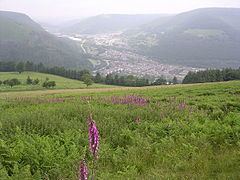
Crosskeys is seven miles north west of Newport, just past Risca off the A467 road. Located near to the confluence of the Ebbw River and the Sirhowy River, it was originally called Pont-y-cymer. The name 'Crosskeys' is taken from the name of the local hotel.
History and amenities
Crosskeys is a South Wales Valleys community, within the historic boundaries of Monmouthshire, once part of the coal mining community of the South Wales coalfield, now a quiet area complete with a residents' society. It has a large park in the lower part and listed buildings in neighbouring Pontywaun, which is normally considered as part of Crosskeys.
Many of the secondary school pupils attend nearby Cwmcarn High School. It is also home to Coleg Gwent's Crosskeys Campus.
Additionally, it has a local rugby union team, Cross Keys RFC, and consequently many different age-banded teams such as youth and mini rugby.
Crosskeys is close to the Cwmcarn Forest Drive which has extensive mountain-biking trails. There is a large local park toward the lower part of the village. The park is home to the local cricket club, again with age-banded youth teams as well as the men's team. There is also a park and a multiple-sports facility.
Sirhowy Valley Country Park is also easily accessible from Crosskeys. It is a base for walking or cycling with access to Flatwoods Meadows Local Nature Reserve. There is also mountain bike trails, a traditional working hill farm that is open to school visits and a small farm trail. Nearby Craig Coch is an ancient mixed woodland.
Due to the re-opening of the Ebbw Valley Railway, Cross Keys railway station was one of six stations opened on the line in February 2008. The original Crosskeys station had two platforms and a set of steps in-between them as the one was considerably higher than the other. This was due to the one line running to Ebbw Vale and the other to Blackwood and Oakdale
The junction between the main Ebbw Vale and Tredegar roads is called Pennyless Corner as it was a meeting place for unemployed men during the great depression of the 1920s
The Tredegar Arms public house is more commonly known as the Monkey, although no reference can be seen in the pub signage. A local story tells how an organ grinder used to spend the money he'd earned around the valleys in the pub, whilst his monkey was tied up outside on the organ.
Melbourne connection
A pub / hotel in suburban Melbourne, Australia was named after the South Wales village. It is rumoured among pub locals that the original owner was from Crosskeys.