
OS grid reference SU792524 Sovereign state United Kingdom | Civil parish Crookham Village Dialling code 01252 | |
 | ||
Population 3,648 (2001 Census)4,037 (2011 Census) | ||
Taylor wimpey crookham village knight close
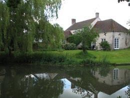
Crookham Village is located south-west of Fleet, in northeast Hampshire, England and lies within the Hart District.
Contents
Map of Crookham Village, UK
History
Crookham (formerly Crokeham) dates back at least as far as the Domesday Book, although Crookham Village and Church Crookham did not become separate entities until the founding of the Christ Church in 1840. It is this church for which Church Crookham is named. Whilst Church Crookham has become largely subsumed in the urban dormitory town of Fleet, Crookham Village lies across the Basingstoke Canal from its neighbour, in a more rural setting.
The village centre has evolved around scattered ancient cottages, many of which are timber-framed. Agriculture and horticulture are important industries, and hops were grown and kiln-dried in the parish until 1974. Crookham was formerly noted for brick making and potteries which produced coarse red ware of the flower-pot-type. A traditional Mummers play is performed outside two of the public houses and on the village green each Boxing Day.