
Population 8,479 (2011 Census) Civil parish Church Crookham UK parliament constituency Aldershot | OS grid reference SU810523 Sovereign state United Kingdom Local time Tuesday 12:38 AM Dialling code 01252 | |
 | ||
Weather 6°C, Wind W at 16 km/h, 86% Humidity | ||
Church crookham fleet hants 8mm 1969 1974
Church Crookham is a large suburban village and civil parish contiguous with the town of Fleet, in northeast Hampshire, England, located 39 miles (63 km) southwest of London. Formerly a separate village and now generally considered as a southern suburb of Fleet, the area comprises one of the 18 wards of the Hart District, in addition to parts of two others. The southwest of the village incorporates the Zebon Copse housing development constructed in the late-1980s.
Contents
- Church crookham fleet hants 8mm 1969 1974
- Map of Church Crookham UK
- History
- The Second World War
- Education
- References
Map of Church Crookham, UK
History
Crookham (formerly Crokeham) dates back at least as far as the Domesday Book, though Church Crookham and Crookham Village did not become distinct entities until the founding of the Christ Church in 1840. It is this church for which Church Crookham is named.
The region had few inhabitants at this time, with the 1831 edition of Samuel Lewis's "Topographical Dictionary of England" claiming Crookham had 623 inhabitants and not even mentioning the (at the time) much smaller Fleet. The settlements in area, particularly Fleet, experienced a minor population bloom in 1840 when a railway station was built at nearby Fleet Pond; while this was primarily for the benefit of day-trippers, many Londoners enjoyed the area so much that they decided to settle there.
The Second World War
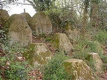
Church Crookham lies on GHQ Line – the most important of a number of fortified stop lines constructed as a part of British anti-invasion preparations of World War II – and was at one of the most heavily fortified sections of that line.
Education
For a list of local schools see the list of Hampshire schools.