
 | ||
Cregagh bonfire part 5
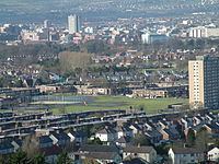
Cregagh (from Irish an Chreagaigh, meaning 'the rocky place') is an area southeast of Belfast in County Down, Northern Ireland. It is the name of a townland and has been adopted as the name of an electoral ward of the Borough of Castlereagh. The townland dates back to mediaeval times, when it was part of the territory held by the O'Neills of Clannaboy. The area is centred on the Cregagh Road. The Woodstock/Cregagh Road is a continuous arterial route in the city, with the Woodstock making up the lower half of the route and the Cregagh the upper half. It runs from the Albertbridge Road, close to the Short Strand, to the A55 Outer Ring road.
Contents
- Cregagh bonfire part 5
- Bonfire at cregagh estate with toxic tyres
- Woodstock Road
- Lower Cregagh Road
- Cregagh Estate
- Upper Cregagh Road
- Notable people
- Politics
- Transport
- References
Bonfire at cregagh estate with toxic tyres
Woodstock Road
The Woodstock Road forms the beginning of the continuous road that includes Cregagh and which runs from close to the River Lagan to the outskirts of Belfast. The road begins at the end of Woodstock Link, which itself starts at a junction which turns off from the Albertbridge Road facing Mountpottinger Road. The Mount, a prominent conference facility built in 1997, is located close to this junction on the Woodstock Link. Following the junction with the Beersbridge Road the Woodstock Road is mainly lined with shops and other places of business. The area, also known as Willowfield, is also home to a number of churches, including the Church of Ireland place of worship Willowfield Parish Church, Saint Anthony's Roman Catholic Church. and the Cregagh Gospel Hall. Other amenities include a public library and a Police Service of Northern Ireland station. The Willowfield area formerly lent its name to the Belfast Willowfield constituency of the old Parliament of Northern Ireland.
An Ulster loyalist flute band, Crimson Star, is based in the area and their badge is shown on a mural painted on a wall on Ardenvohr Street just off the Woodstock Road. During the Troubles notorious Ulster Volunteer Force hitman Robert "Squeak" Seymour ran a video shop on the Woodstock Road. It was whilst working at his shop that Seymour was shot and killed by two Provisional Irish Republican Army operatives on 15 June 1988.
The Woodstock Road continues as far Ravenhill Avenue when it becomes the Cregagh Road. The Woodstock Road was formerly known as the lower Cregagh Road and in the nineteenth century it was mainly made up of farmland. Until the 1920s parts of the Cregagh Road, which is now entirely urbanised, were agricultural.
Lower Cregagh Road
At its lower stage the Cregagh Road largely continues in the same vein as the Woodstcok Road, being lined with several shops. This area also has a number of churches, the most prominent of which are Cregagh Methodist Church and Cregagh Presbyterian Church.
Just off the Cregagh Road are two locally well-known sporting venues, Cregagh Cricket Club and Malone Rugby Club. While having separate facilities, they are situated on the same road, namely Gibson Park Avenue. Cregagh Cricket Club celebrated its centenary in 2006. The cricket ground is also used by Northern Amateur Football League club Orangefield Old Boys' Association F.C. and is part of Cregagh Sports Club, effectively a merger of the cricket and association football clubs, with both sharing the same Gibson Park Avenue facilities. This alliance was concluded in the early 1980s, with the two clubs being previously unconnected. Ravenhill Stadium, the home of Ulster Rugby, lies a short distance away, about halfway between the Cregagh Road and the Ravenhill Road to the east.
Cregagh Estate
The Cregagh Estate is located off the Cregagh Road, starting after the roundabout junction with Ladas Drive and Mount Merrion Avenue. The junction is immediately after Bell's Bridge which crosses the River Loop, one of Belfast's myriad minor rivers. The estate was built as a public housing project in 1946–1947 and was designed by government architect T. F. O. Rippingham. Tenants have subsequently been offered the opportunity to purchase their homes. The estate is characterised by its uncommon flat roofs and staggered house fronts. The streets in the Cregagh Estate are named after the rivers and streams of the island of Ireland (e.g. Callan Way, Kilbroney Bend).
Although predominantly Protestant from its inception, Cregagh had a significant Catholic minority for a number of years and at the start of the Troubles, Catholics even joined in local vigilante patrols under the auspices of the Cregagh Tenants Association. This co-operation ended in 1972 with the arrival of the Ulster Defence Association (UDA) and before long most of the Catholic residents had left the area for west Belfast. Around this time housing allocation in the area came under UDA control and the local "Tartan gangs" were taken over as the junior UDA. Subsequently however the UDA declined in the area, and east Belfast in general, and the Ulster Volunteer Force became more important, with UVF murals being painted on Cregagh's walls. Contemporaneously however the only murals on Cregagh estate are one commemorating Victoria Cross winners Eric Norman Frankland Bell, Geoffrey Cather, William McFadzean and Robert Quigg and another showing local boy George Best.
Upper Cregagh Road
Beyond the Cregagh estate the road is made up of mainly private housing and continues as far as Upper Knockbreda Road. Cregagh Library and the former home of Castlereagh Borough Council are found on this part of the road. The latter building has been extensively refurbished and is now the Museum Of Orange Heritage. The neighbouring Montgomery Road is the location for the former Robinson Centre leisure facility and the Castlereagh campus of Belfast Metropolitan College. The area was sometimes nicknamed the "Bible belt". Immediately beyond the end of the Cregagh Road, on the opposite side of the Upper Knockbreda Road, is a forested area known as Cregagh Glen. The Upper Knockbreda Road, otherwise known as the A55 Outer Ring, was completed in 1967 to link Cregagh with the Knock area on the outskirts of east Belfast.
Some of the streets in Cregagh are named after Second World War generals (e.g. Montgomery, Alanbrooke) while a significant number are named after First World War battlefields (e.g. Picardy, Hamel). This connection with the wars reflects the numbers of people from the area who died in those wars. This was also a reason why the location was chosen for a large number of ex-servicemen's homes, with 150 of the so-called "homes fit for heroes" promised by David Lloyd George built around this area in the late 1920s. However this area, which was known locally as "the Colony", remained the only significant public housing scheme for ex-soldiers to be undertaken in Belfast in the aftermath of the First World War.
A memorial to the dead of the First World War, consisting of a Celtic Cross, was unveiled in 1929 before being rededicated in 1932 by Edward, Prince of Wales. Castlereagh council expanded the memorial a number of times during the 1990s, adding a stone for the Ulster Special Constabulary, another stone for the Ulster Defence Regiment and a back plaque commemorating members of both of these groups and the Royal Ulster Constabulary as well as civilians killed during the Troubles and local residents who died during the Second World War.
Notable people
The late footballer George Best grew up in the Cregagh Estate, and as a boy played football on the open playing fields at the centre of the estate. Best's funeral originated from Burren Way where his father still lived up until his death in April 2008. George Best is commemorated by a mural in the Cregagh estate and formerly by another on the Woodstock Road.
Singer-songwriter David McWilliams, who achieved mainstream success with his song "Days of Pearly Spencer", was born in the Cregagh estate although he moved to Ballymena at an early age.
Democratic Unionist Party (DUP) Iris Robinson grew up on the Cregagh estate and met her husband, future First Minister of Northern Ireland Peter Robinson, when they both attended Castlereagh College. The Robinson Centre is also named after Peter Robinson.
Politics
The Woodstock and Cregagh roads are part of the East Belfast constituency for Westminster and the same constituency for Stormont. The Westminster seat was held by Naomi Long of the Alliance Party of Northern Ireland (APNI) until May 2015, when she lost her seat to Gavin Robinson of the DUP. The seats in the multi-member Assembly constituency are occupied by Michael Copeland (Ulster Unionist Party), Sammy Douglas (DUP), Judith Cochrane (APNI), Chris Lyttle (APNI), Robin Newton (DUP) and Peter Robinson (DUP).
For local government the area is divided between Belfast City Council and Castlereagh Borough Council. The Belfast section is part of the Pottinger District Electoral Area with the seats held by May Campbell, Adam Newton and Gavin Robinson of the DUP, Máire Hendron of APNI, Niall Ó Donnghaile of Sinn Féin and John Kyle of the Progressive Unionist Party. The Castlereagh section is in the Castlereagh Central area, with the seats held by Vivienne McCoy, Tommy Sandford and Denny Vitty of the DUP, Carole Howard and Michael Long of the APNI and Michael Copeland of the Ulster Unionists. Sandford, a former UVF prisoner who became a community worker in Cregagh, had been a member of the Progressive Unionist Party but left that group in 2009 over its continuing links to the loyalist paramilitary group, joining the DUP the following year.
Transport
Woodstock and Cregagh are served by Service 6 of the Metro buses provided by Translink which links the areas with Belfast city centre at one end and Forestside Shopping Centre at the other.