
- location Port Credit - average 8.12 m/s (287 cu ft/s) Discharge 8.12 m³/s Mouth Lake Ontario Country Canada | - elevation 74 m (243 ft) - min 0.085 m/s (3 cu ft/s) Length 90 km Province Ontario | |
 | ||
- location near Orangeville, Ontario and Caldeon East, Ontario - max 501 m/s (17,693 cu ft/s) Cities Mississauga, Brampton, Caledon, Port Credit, Halton Hills, Orangeville, Mono, East Garafraxa, Amaranth, Ontario Similar Lake Ontario, Forks of the Credit Provincial, Etobicoke Creek, Humber River, Erin Mills Town Centre | ||
400 m (1,312 ft)
Contents
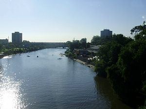
- Map of Credit River Mississauga ON Canada
- NamingEdit
- Watershed population and land useEdit
- Plants and animalsEdit
- In popular cultureEdit
- References
Map of Credit River, Mississauga, ON, Canada
The Credit River is a river in southern Ontario which flows from headwaters above the Niagara Escarpment near Orangeville and Caledon East to empty into Lake Ontario at Port Credit, Mississauga. It drains an area of approximately 1,000 square kilometres (390 sq mi). The total length of the river and its tributary streams is over 1,500 kilometres (930 mi).
Despite urbanization and associated problems with water quality on the lower section of this river, it provides spawning areas for Chinook salmon and rainbow trout. There is a fish ladder on the river at Streetsville. Much of the river can still be travelled by canoe or kayak. The headwaters of the Credit River is home to a native self-sustaining brook trout population and an introduced brown trout population.
Credit Valley Conservation, the local watershed management conservation authority, operates several Conservation Areas including Belfountain, Island Lake, and Terra Cotta.
Forks of the Credit Provincial Park is located on the upper part of the river between Brampton and Orangeville, and is near the Bruce Trail.
Communities in the river's watershed include:
NamingEdit
The river became known as Missinnihe, or "trusting creek" to the Mississauga First Nation people who met annually with white traders there. To the first nations, the river was "held in reverential estimation as the favourite resort of their ancestors" and the band, which ranged from Long Point on Lake Erie, to the Rouge River on Lake Ontario, became known as the Credit River Indians. Their descendents are today the Mississaugas of the New Credit First Nation.
The origins of the English name come from the time when French fur traders supplied goods to the native people in advance (on credit) against furs which would be provided the following spring. It was known as the Rivière au Crédit. The trading post was set up at the mouth of the river, in Port Credit, in the early 18th century.
Watershed population and land useEdit
As of the 2006 census, 750,000 people live in the watershed. Of those, 87 percent live in the lower third of the watershed. Population growth is approximately 3 percent per year. In 1999, 21 percent of the watershed was developed. By 2020, 40 percent of the watershed will be developed (based on approved development and the official plans of the municipalities).
Plants and animalsEdit
The Credit River is home to a wide range of wildlife. Some species are permanent or seasonal residents while others are sighted occasionally. 1330 species of plants, 64 fish species (including many bait fish, pike, and brook trout), 41 species of mammals, 5 species of turtles, 8 snake species, 17 amphibian species, and 244 species of birds call this watershed home.
In popular cultureEdit
The Canadian indie rock band The Constantines entitled a track "Credit River" on their 2008 album Kensington Heights.