
Parent peak Brush Mountain Elevation 458 m | Age of rock 400.265424 million years | |
 | ||
Similar Mount Grace, Tully Mountain, Little Monadnock Mountain, Farley Ledges, Mount Norwottuck | ||
Crag mountain massachusetts top 5 facts
Crag Mountain, 1,503 feet (458 m), of the Bald Hills region of east Franklin County, Massachusetts is the southern and most apparent summit of Brush Mountain, 1,507 feet (459 m). Narrow and precipituous, the mountain offers expansive views from its open, knife-edge summit. Crag Mountain is composed of quartzite, a weather-resistant metamorphic rock. The 114 mile (183 km) Metacomet-Monadnock Trail traverses its summit ridge. Crag Mountain is located within the town of Northfield, Massachusetts.
Contents
- Crag mountain massachusetts top 5 facts
- Map of Crag Mountain Northfield MA 01360 USA
- RecreationEdit
- References
Map of Crag Mountain, Northfield, MA 01360, USA
The west side of Crag Mountain flows into Fourmile Brook, then into the Connecticut River, which flows into Long Island Sound. The east side flows into Jack's Brook and Keyup Brook, then into the Millers River, thence the Connecticut River and Long Island Sound.
RecreationEdit
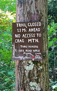
Currently (August 2013), the Crag Mountain summit is closed to thru hikers on the M & M Trail at the request of the landowner. The trail remains blazed from Gulf Road in a southerly direction to within a half mile of the summit that is marked with two USGS benchmarks.