
Interest Biological/Geological | Grid reference SW785189 Notification 1951 | |
 | ||
Area 173.46 hectares (1.735 km; 0.6697 sq mi) | ||
Coverack to Porthoustock is a coastal Site of Special Scientific Interest (SSSI) in Cornwall, England, UK, noted for both its biological and geological characteristics. The site contains 4 Red Data Book plant species.
Contents
Geography
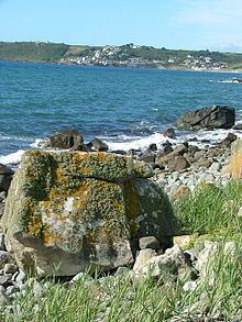
The 173.5-hectare (429-acre) site, notified in 1951, is situated on the south Cornish coast, within St Keverne civil parish on the Lizard Peninsula. It starts at the village of Coverack in the south, following the shores of the English Channel to the hamlet of Porthoustock in the north.
The South West Coast Path runs through the SSSI, part of the coastline around Lowland Point is owned by the National Trust and contains 2 Geological Conservation Review sites.
Wildlife and ecology
The coastline contains 4 Red Data Book plant species, which includes Cornish heath (Erica vagans), dwarf rush (Juncus capitatus) and twin-headed clover (Trifolium bocconei) along with the nationally scarce autumn squill (Scilla autumnalis).