
Type Formation Member | ||
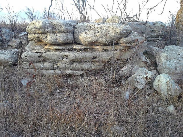 | ||
Sub-units Top Ledge, Bottom Ledge Thickness 3 to 7 feet, often about 6 feet | ||
Cottonwood Limestone, or simply the Cottonwood, is a stratigraphic unit and a historic stone resource in east-central Kansas, northeast-central Oklahoma, and southeastern Nebraska in the Midwestern United States. It is the lowest member of the Beattie Limestone formation and commonly outcrops within the deep valleys and on top of the scenic residual ridges of the Flint Hills.
Contents
This important building stone, quarried in the Cottonwood River valley, had been used under the names "Cottonwood stone" or "Cottonwood Falls limestone" many years before the name Cottonwood Limestone appeared in scientific publications late in the 19th century. Similarly, "Manhattan stone" was the commercial name used for the same limestone when quarried in the vicinity of Manhattan, Kansas. It was also called "Alma Limestone" when first quarried at Alma, Kansas.
The Cottonwood Limestone is one of the most persistent and easily recognizable horizons in Kansas. This limestone is usually light gray or buff in color, massively bedded, and has an average thickness of about six feet. The upper part of the member in particular is recognizable for being almost entirely made up of the small wheat-grain shaped foraminifera Fusulinida, with few other animal remains. The line of outcrop of the Cottonwood is generally marked by a line of massive rectangular blocks of light gray or bleached, bone-colored limestone, often supporting a line of shrubs. Because of its resistance to weathering, it often forms a prominent escarpment. The Cottonwood Limestone is noteworthy for the persistence of this lithologic character across its range.
Distribution
As the prominent member of the Beattie Limestone formation, Cottonwood Limestone can be traced on the outcrop from Nemaha County, Nebraska, southward to Osage County, Oklahoma, and followed in the subsurface westward to the vicinity of the Colorado-Kansas line as well as into northwestern Oklahoma.
The surface outcropping of the Cottonwood Limestone is easily traced in the Flint Hills south of the Kansas River and east of Manhattan, Kansas. In Manhattan, it forms the scenic ridges surrounding the old downtown in the southeast of the city. From there, the line of outcrop is a tortuous one extending several miles north and west along the Kansas and Big Blue rivers and their tributaries.
This limestone forms extensive outcrops in the Cottonwood River valley that shares its name; outcrops can be followed several miles up every tributary valley around Cottonwood Falls.
Lithologic character and thickness
The Cottonwood Limestone is a marine limestone and calcareous shale, laterally persistent, bench-forming, and notably and consistently showing abundant fossils. An outstanding example of uniformity of thickness over considerable areas, the outcrop of the Cottonwood Limestone over a distance of 150 miles from Nebraska to central Kansas is nowhere less than 5.5 nor more than 6.5 feet. The notable consistency of these characteristics within its range serves to make it a distinctive marker bed. Even so, there are some changes in lithologic character that can be seen from north to south.
In the central and north range, the limestone is recognized to have distinct the upper and lower beds, long known as Top Ledge and Bottom Ledge, which commonly part when weathered. This boundary between the upper and lower Cottonwood is evidenced by a sharp textural contrast, porosity difference, and changes in the opaque mineral content. In this range, the whole member is fine-grained limestone, but the Top Ledge has a yellower tint or a creamy gray with open grain while the Bottom Ledge is whiter with tight grain. With respect to fossil content, the upper weathering bed is characterized by the abundant Fusulinid assemblage, while the lower bed is composed of minute particles of various fragmented fossils, especially Osagia, echinoderms, and bryozoans.
In northern east-central Kansas, Cottonwood Limestone forms particularly prominent outcroppings in the Flint Hills, especially in the Cottonwood River valley in Chase County, Neosho River valley in Morris County, and the Kansas River and Big Blue River valleys of Riley County. There, it often forms a very conspicuous hillside bench characterized by massive light-gray rounded limestone blocks. The presence of the Cottonwood Limestone in a hillside here is often marked by a persistent line of shrubs that can be seen for many miles. Wherever seen in these and nearby valleys, the Cottonwood Limestone member is almost uniformly six feet thick. It is everywhere massive and commonly seems to consist of only one or two beds. The limestone on a fresh fracture is yellowish gray to buff in color, weathering to light gray. Fusulinids are common, especially in the upper part, and siliceous nodules project from weathered surfaces. Close observation removes any likelihood of confusing the Cottonwood Limestone with any other layer in this part of Kansas; its distinguishing characters are the massive ledge of uniform thickness, the silicified nodules, and the abundance of fusulinids, chiefly in the resistant upper part. The Cottonwood is not a flinty limestone such as those seen higher on the surrounding hilltops; however, nodules, concretions, and trace fossils (filled-in burrows) of partly silicified material that weather more slowly than the rest of the member can give the limestone an appearance of containing flint.
While the abundance of fusulinids remains a characteristic of the top of the Cottonwood through to Osage County, Oklahoma, south of Chase County, Kansas the member has lost its massive limestone characteristic and does not form the conspicuous outcrops seen farther north. In Greenwood County, Kansas, the unit appears as light-gray limestone crowded with horizontal thin leaves of platy algae, attaining a maximum observed thickness of 8 feet. The Cottonwood in southern Kansas and northern Oklahoma is an interbedded limestone and calcareous shale with a very diverse, abundant, and well-preserved fossil fauna, especially brachiopods, mollusks, and ammodiscid foraminifera (shelly facies). At the southern limit of its outcrop the Cottonwood Limestone is a medium crystalline limestone with thin, shelly layers. Mollusks, Osagia, and quartz silt are common (silty Osagia facies).
Paleoenvironment
Variations in the characteristic content and texture (facies) of the limestone reflect lateral changes in the environment from north to south.
Access and viewing
The Cottonwood Limestone is easily accessed or viewed in several locations: