
Time zone Pacific (PST) (UTC-8) Elevation 84 m Population 7,592 (2013) Area code 530 | Incorporated August 6, 1907 ZIP codes 96021, 96029 Area 9.19 km² Local time Monday 6:20 AM | |
 | ||
Weather 5°C, Wind SE at 21 km/h, 84% Humidity | ||
Corning is a city in Tehama County, California that is located about 19 miles south of Red Bluff and about 500 miles north of Los Angeles. The population was 7,663 at the 2010 census, up from 6,741 at the 2000 census.
Contents
- Map of Corning CA 96021 USA
- Geography
- Climate
- 2010
- 2000
- Government
- Major industries
- Corning Olive Festival
- Transportation
- Notable people
- References
Map of Corning, CA 96021, USA
Geography
Corning is located at 39°55′34″N 122°10′50″W (39.926182, -122.180489).
According to the United States Census Bureau, the city has a total area of 3.55 square miles (9.2 km2), all of it land.
Climate
According to the Köppen Climate Classification system, Corning has a warm-summer Mediterranean climate, abbreviated "Csa" on climate maps.
2010
The 2010 United States Census reported that Corning had a population of 7,663. The population density was 2,158.8 people per square mile (833.5/km²). The racial makeup of Corning was 5,510 (71.9%) White, 44 (0.6%) African American, 201 (2.6%) Native American, 82 (1.1%) Asian, 11 (0.1%) Pacific Islander, 1,496 (19.5%) from other races, and 319 (4.2%) from two or more races. Hispanic or Latino of any race were 3,271 persons (42.7%).
The Census reported that 7,638 people (99.7% of the population) lived in households, 19 (0.2%) lived in non-institutionalized group quarters, and 6 (0.1%) were institutionalized.
There were 2,630 households, out of which 1,193 (45.4%) had children under the age of 18 living in them, 1,136 (43.2%) were opposite-sex married couples living together, 533 (20.3%) had a female householder with no husband present, 179 (6.8%) had a male householder with no wife present. There were 224 (8.5%) unmarried opposite-sex partnerships, and 12 (0.5%) same-sex married couples or partnerships. 633 households (24.1%) were made up of individuals and 259 (9.8%) had someone living alone who was 65 years of age or older. The average household size was 2.90. There were 1,848 families (70.3% of all households); the average family size was 3.44.
The population was spread out with 2,479 people (32.4%) under the age of 18, 864 people (11.3%) aged 18 to 24, 1,931 people (25.2%) aged 25 to 44, 1,617 people (21.1%) aged 45 to 64, and 772 people (10.1%) who were 65 years of age or older. The median age was 29.2 years. For every 100 females there were 94.5 males. For every 100 females age 18 and over, there were 89.5 males.
There were 2,871 housing units at an average density of 808.8 per square mile (312.3/km²), of which 1,302 (49.5%) were owner-occupied, and 1,328 (50.5%) were occupied by renters. The homeowner vacancy rate was 3.1%; the rental vacancy rate was 8.4%. 3,765 people (49.1% of the population) lived in owner-occupied housing units and 3,873 people (50.5%) lived in rental housing units.
2000
As of the census of 2000, there were 6,741 people, 2,422 households, and 1,642 families residing in the city. The population density was 2,320.3 people per square mile (894.4/km²). There were 2,614 housing units at an average density of 899.8 per square mile (346.8/km²). The racial makeup of the city was 74.48% White, 0.52% African American, 2.18% Native American, 0.53% Asian, 0.09% Pacific Islander, 17.42% from other races, and 4.78% from two or more races. Hispanic or Latino of any race were 50.82% of the population.
There were 2,422 households out of which 40.2% had children under the age of 18 living with them, 45.1% were married couples living together, 16.3% had a female householder with no husband present, and 32.2% were non-families. 26.9% of all households were made up of individuals and 14.0% had someone living alone who was 65 years of age or older. The average household size was 2.76 and the average family size was 3.33.
In the city, the population was spread out with 32.5% under the age of 18, 10.0% from 18 to 24, 28.0% from 25 to 44, 17.7% from 45 to 64, and 11.8% who were 65 years of age or older. The median age was 31 years. For every 100 females there were 92.9 males. For every 100 females age 18 and over, there were 90.5 males.
The median income for a household in the city was $25,357, and the median income for a family was $32,151. Males had a median income of $30,563 versus $19,736 for females. The per capita income for the city was $12,357. About 21.1% of families and 26.3% of the population were below the poverty line, including 33.6% of those under age 18 and 15.6% of those age 65 or over.
These compare to the national median household income of $45,135 and national per capita income of $23,201. 69.4% of the Residents in the city have graduated from High School or achieved further education compared to 80.35% nationally.
Government
In the California State Legislature, Corning is in the 4th Senate District, represented by Republican Jim Nielsen, and in the 3rd Assembly District, represented by Republican James Gallagher.
In the United States House of Representatives, Corning is in California's 1st congressional district, represented by Republican Doug LaMalfa.
Major industries
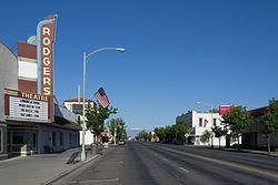
Corning is home to Bell-Carter Foods, Inc., the second-largest table olive processor in the world and the largest in the United States. Bell Carter produces Lindsay Olives. In addition to table olives, Corning also has a significant agricultural industry based on olive oil, dried plums (prunes) including the Sunsweet label, walnuts, and almonds. Lucero Olive Oil, North American's most award-winning extra virgin olive oil company, is based here with orchards, olive mill, and a public Tasting Room. The Olive Pit is another local landmark specializing in many varieties of table olives, and is a popular tourist stop with a wine bar and cafe. Other destinations include the House of Brews, a music-based coffee shop, the historic Rodgers Theater, and the Corning Museum. Rolling Hills Casino, Equestrian Center, and Sevillano Links Golf Course, a championship 18-hole golf course, is about one mile south of town.
Corning Olive Festival
The first annual Corning Olive Festival was held in 1946 by the local Catholic church as a fundraiser and is the longest running olive festival in the United States. Now organized and operated by the Corning Chamber of Commerce, the city plans to offer the festival the 2nd weekend in October each year.
Transportation
Interstate 5 and Highway 99 both serve Corning, along with the California Northern Railroad. The California Northern has been leasing and operating the 110.7-mile (178.2 km) line between Davis and Tehama county through Corning from Southern Pacific (now Union Pacific) since September 26, 1993. The line was built by Southern Pacific's subsidiary, the Northern Railway Company, in August/September 1882.