
Time zone WET (UTC+0) Area 109.3 km² | Irish Grid Reference N415619 | |
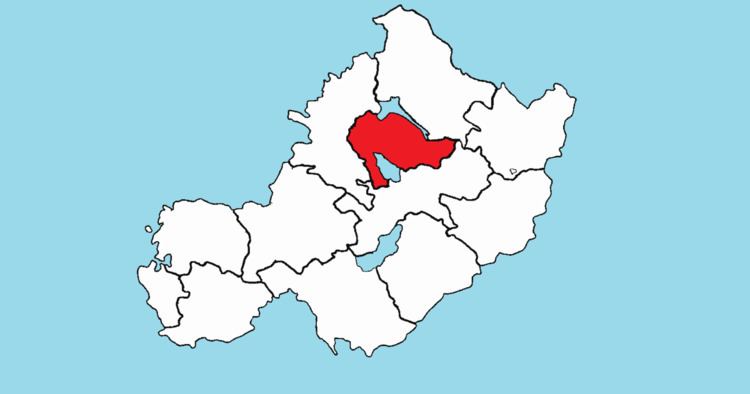 | ||
Corkaree (Irish: Corca Raoi) is a barony in north County Westmeath, in the Republic of Ireland. It was formed by 1672. It is bordered by three other baronies: Fore (to the north), Moyashel and Magheradernon (to the south) and Moygoish (to the west).
Contents
Early history
In the Medieval period the area of Corcaree formed part of the lands held by the Ó Dálaigh (Daly) bardic family. Máel Íosa Ua Dálaigh, died 1185, was described as “Chief poet of Ireland and Scotland," he was also lord (ard taoiseach) of the 'minor midland kingdom' of Corca Raidhe (Corcaree). The annals state that in 1185, Maelisa O'Daly, ollave (chief poet) of Ireland and Scotland, Lord of Corcaree and Corca-Adain, a man illustrious for his poetry, hospitality, and nobility, died while on a pilgrimage at Clonard.
Geography
Corkaree has an area of 26,996.9 acres (109.253 km2).
The barony contains two large lakes; Lough Derravaragh, shared with the barony of Fore, and home to the Irish legend of the Children of Lir and Lough Owel an internationally recognised Ramsar waterfowl habitat. In addition Lough Iron, a small lake, lies on the River Inny and is shared with the barony of Moygoish. The lake is not easily accessible as there is no road close to the lake or public access.
The River Inny, flows into Lough Derravaragh, then near the village of Ballinalack. The River Brosna, rises in Lough Owel and, like the Inny, is a tributary of the River Shannon.
The N4, a national primary road passes to the north of Lough Owel, connecting Dublin with the north–west of Ireland and the coastal town of Sligo. A railway line carrying the national rail company Iarnród Éireann's Dublin to Longford commuter service and Dublin to Sligo intercity service also passes through the barony.
Civil parishes of the barony
This table lists an historical geographical sub-division of the barony known as the civil parish (not to be confused with an Ecclesiastical parish).
Towns, villages and townlands
There are 77 townlands in the barony of Corkaree.