
- elevation 1,034 m (3,392 ft) - average 6.04 m/s (213 cu ft/s) Country Canada | - elevation 4 m (13 ft) - min 0.025 m/s (1 cu ft/s) Bridges Eleanor Ward Bridge | |
 | ||
- max 476 m/s (16,810 cu ft/s) | ||
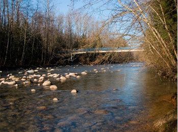
Coquitlam river time lapse
The Coquitlam River (/koʊˈkwɪtləm/ or /kəˈkwɪtləm/) is a tributary of the Fraser River in the Canadian province of British Columbia.
Contents
- Coquitlam river time lapse
- Map of Coquitlam River British Columbia Canada
- Salmons of coquitlam river
- CourseEdit
- References
Map of Coquitlam River, British Columbia, Canada
The river's name comes from a Halkomelem word meaning "stinking of fish slime". A traditional story tells of the Coquitlam people selling themselves into slavery during a winter famine. While butchering salmon for their masters they would be covered with fish slime.
Each year hundreds of salmon return to spawn in the Coquitlam River.
Part of the Port Coquitlam Tributary Trail and the Trans Canada trail run alongside this river. The Indian reserves of the Kway-quit-lum people of the Coquitlam Indian Band are also located along the river.
Salmons of coquitlam river
CourseEdit
The Coquitlam River originates at Disappointment Lake in the Coast Mountains near Indian Arm. It flows south into Coquitlam Lake, a reservoir behind Coquitlam Dam, which provides a large portion of Vancouver's drinking water. The upper portion of the river and Coquitlam lake are part of the Metro Vancouver watershed. Below the dam the Coquitlam River continues to flow south, reaching the Fraser River between the cities of Coquitlam and Port Coquitlam, suburban municipalities located in Metro Vancouver.