
Country Chile Time zone CLT (UTC-4) Area 32,538 km² | Area code(s) 56 + 52 Capital Copiapó Team Deportes Copiapó | |
 | ||
Points of interest Ojos del Salado, Laguna Verde, Nevado Tres Cruces, San Francisco Pass, Incahuasi | ||
Pachamama by bus caldera copiap province atacama region chile south america
Copiapó Province (Spanish: Provincia de Copiapó) is one of three provinces of the northern Chilean region of Atacama (III). Its capital is the city of Copiapó.
Contents
- Pachamama by bus caldera copiap province atacama region chile south america
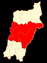
- Map of CopiapC3B3 Province Atacama Region Chile
- Geography and demography
- Administration
- Communes
- References
Map of Copiap%C3%B3 Province, Atacama Region, Chile
Geography and demography
According to the 2012 census by the National Statistics Institute (INE), the province spans an area of 32,538.5 km2 (12,563 sq mi) and had a population of 183,973 inhabitants, giving it a population density of 4.8/km2 (12/sq mi). It is the tenth largest province in the country. Between the 1992 and 2002 censuses, the population grew by 24.9% (31,021 persons).
Administration
As a province, Copiapó is a second-level administrative division of Chile, which is further divided into three communes (comunas). The province is administered by a presidentially appointed governor. Nicolás Noman Garrido was appointed by president Sebastián Piñera.
Communes
- Copiapó
- Caldera
- Tierra Amarilla