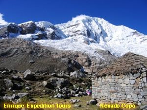
Elevation 6,188 m Prominence 1,390 m Mountain range Cordillera Blanca, Andes | First ascent 26 September 1932 Parent range Cordillera Blanca | |
 | ||
Similar Urus, Quitaraju, Tocllaraju, Vallunaraju, Chopicalqui | ||
Copa (possibly from qupa, a Quechua word for the mineral turquoise and the turquoise color) is a mountain in the Andes of Peru whose summit reaches about 6,188 metres (20,302 ft) above sea level. It is situated in the Ancash Region, Asunción Province, Chacas District, and in the Carhuaz Province, Marcará District, south-east of Hualcán.
Contents
Map of Qupa, Peru
Lake Allicocha lies south-east of Copa while Lake Lejiacocha is located to the south-west of the mountain. Legiamayo River originates from mount Copa, in the area nearby Lake Lejiacocha.
Alternative namesEdit
Copa is also named Chucushcaraju (possibly from Quechua chukuy to make someone put a headdress on / crouch, bend down, -sqa a suffix, rahu snow, ice, mountain with snow, "headdressed mountain with snow" or "crouched mountain with snow"), Pamparaju (possibly from Quechua pampa a large plain, "plain mountain with snow") or Carhuacatac (possibly from Quechua qarwa leaf worm, larva of a beetle / pale / yellowish / golden, qataq someone who covers someone or something with a blanket, t'aqaq sower).
