
Postcode(s) 5261 Federal Division(s) Barker Postal code 5261 Lga Coorong District Council | State electorate(s) MacKillop Elevation 16 m Local time Monday 8:48 AM | |
 | ||
Weather 17°C, Wind SE at 16 km/h, 73% Humidity | ||
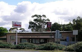
Coomandook is a settlement about 120 kilometres (75 mi) east-south-east of Adelaide on Dukes Highway in South Australia. The nearest place with a larger population is Coonalpyn, which is 29 kilometres (18 mi) away, with a population of around 230.
Map of Coomandook SA 5261, Australia
Coomandook is near the edge of the vast mallee scrub area which stretches from western Victoria across into the south east of South Australia. The most common agricultural industries are sheep, beef cattle rearing and grain growing.
The population of Coomandook was not recorded under that name in the 2006 census, but 134 voters cast their votes in Coomandook during the 2010 Barker division election.
References
Coomandook Wikipedia(Text) CC BY-SA