
Population 7,905 (2011 census) Postal code 4573 | Postcode(s) 4573 Coolum Beach Pacific Ocean Local time Monday 8:16 AM | |
 | ||
Weather 26°C, Wind S at 13 km/h, 71% Humidity Points of interest Sunshine Coast - Queensland, Aqua Park Coolum, Tickle Park, Point Perry, First Bay | ||
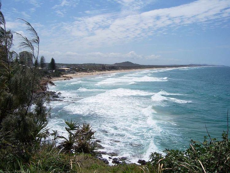
Coolum Beach is a beachside town on the Sunshine Coast in Queensland, Australia and is also the beach around which the town is based.
Contents
Map of Coolum Beach QLD 4573, Australia
History
The name is derived from the local Undumbi word gulum or guloom, meaning "blunt" or "headless", referring to the shape of Mount Coolum, which has no peak. According to Aboriginal legend, Ninderry knocked off Coolum's head and it fell into the ocean and is now Mudjimba Island.
The Coolum district was the traditional land of the Inabara or Yinneburra clan of the Undanbi Tribe. In turn, they were part of the larger group of the Kabi Kabi.
In 1823, the first Europeans to pass through Coolum were castaways and shipwrecked sailors. The first land selection in Coolum was made in 1871 by Grainger Ward - a pastoral lease of 255 hectares. Here, Ward ran upwards of 300 head of cattle. In 1881, Mark Blasdall selected his own lease of 252 hectares. Blasdall was the first to plan sugarcane in the area and to cut timber. He built two huts and a sawmill as well as clearing Coolum Creek, thus enabling steampships to enter to load timber and deliver supplies. By 1882 the steampships 'Tadorna Radjah' and 'Gneering' began to regularly travel from Brisbane to Coolum creek. In 1883 the first Coolum land was freehold and by 1884, Blasdall was declared insolvent and his land freeholded.
The first permanent settler of Coolum was William Perry-Keene and his family in 1905. His home was called "Green Hills" and was situated at the corner of Beach Road, Daytona and Key West Avenues. Between 1906 and 1912 many people settled permanently in the region. By 1912 there were eight to 12 families living in the district. In 1909, Coulsin established a mailboat service on the Maroochy River. This provided the first regular connection between Coolum and the railhead at Yandina. In 1911, a horse-drawn tramline and punt loading facilities were built at Coolum Creek.
Construction of the first paved road to Coolum was undertaken between 1922 and 1925. This provided vehicle access from Coolum to Yandina. In 1923, the tramline to Coolum was opened and unscheduled passenger services began. Over this time considerable expansion of the sugarcane industry took place. Cane farming provided the main source of financial stability in the district until the advent of tourism in the 1960s.
In 2002 Coolum hosted the Commonwealth Heads of Government Meeting, replacing the 2001 meeting that was postponed and moved from Brisbane in the wake of the September 11 attacks.
In 2006 Australian census, the population of Coolum was 7,744.
Geography
Mount Coolum dominates the landscape, and can be seen from most of Coolum. Mt Coolum National Park provides a 1.6 km bush walk up the mountain to 360 degree views of the coast. The track was upgraded in 2012 to improve safety and accessibility.
Education
Coolum State School is located at the entrance to the town off the Sunshine Motorway.
Coolum State High School is located in the town.
Commercial area
Coolum Beach is a popular day trip and holiday destination. The town is focused around the beach which is patrolled by life savers and offers swimming and surfing, in its day it is known as one of the best breaks in Queensland. Parks, a boardwalk, esplanade shops, and the surf lifesaver club surround the beach. Over the last five years Coolum Beach has seen heavy development, with new buildings for retail business and holiday apartments.
In "An Island Surrounded by Land",the white settlement of Coolum is described by Windolf and Windolf (2004),as having occurred, unconnected by road to Maroochydore and Noosa. This gives Coolum, to this day, the friendly feeling of a country town, even though it forms part of an urban strip called the Sunshine Coast. Perhaps the aboriginal history of Coolum endures only in the place names and in the brooding presence of Mount Coolum. Settlement in the 1950s and 1960s was often by working class Brisbane families who first built holiday cottages. Lifestylers joined the mix in the 1970s. This influx confirmed the tolerant society that Coolum had become. Coolum Beach is still a "live and let live" society, with no identifiable ruling group. Whilst Queensland voted conservatively throughout the 1960s, 1970s and 1980s, Coolum Beach has always voted Labor.
Transport
Transport is primarily ran by a sub division of TransLink, named SunBus. There is a train line ran by TransLink which goes from Roma Street railway station, located in Brisbane which takes you to Nambour railway station.
It also includes a secondary line which goes from Ipswich to North Gympie, stopping at popular stations such as Nambour.
Train Services are operated by Queensland Rail (QR)