
- elevation 183 m (600 ft) Basin area 33.9 km² | - elevation 74 m (243 ft) | |
 | ||
Cooksville creek public school mississauga 2016 this land is your land this land is my land
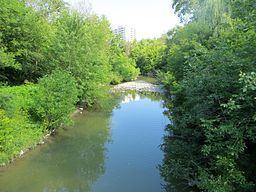
Cooksville Creek is a short stream in Mississauga, Regional Municipality of Peel in the Greater Toronto Area of Ontario, Canada. It begins near Bristol Road West and Hurontario Street and flows south to Lake Ontario at R.K McMilian Park near Lakeshore Road and Cawthra Road. The community of Cooksville is located on the west bank of the creek near Hurontario Street and Dundas Street East. The creek is surrounded mostly by residential homes and a few parks:
Contents
- Cooksville creek public school mississauga 2016 this land is your land this land is my land
- Cooksville creek waterfall in fall 2012
- References
The drainage basin runs for 16 kilometres (9.9 mi), is about 2 kilometres (1.2 mi) wide, has a total area of 33.9 square kilometres (13.1 sq mi), and takes excess water from sanitary and storm sewers. 94% of the drainage basin is built over, and only 6% is open space.
Cooksville creek waterfall in fall 2012
References
Cooksville Creek Wikipedia(Text) CC BY-SA