
- elevation 1,240 ft (378 m) Length 62 km Basin area 740.7 km² | - elevation 874 ft (266 m) Basin area 740.7 km² | |
 | ||
- location Fairfield Township, Tuscarawas County | ||
Conotton creek trail foxes
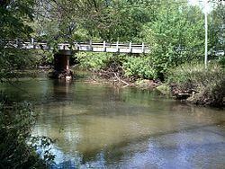
Conotton Creek (pronounced kah--en) is a tributary of the Tuscarawas River, 38.7 miles (62.3 km) long, in eastern Ohio in the United States. Via the Tuscarawas, Muskingum and Ohio Rivers, it is part of the watershed of the Mississippi River, draining an area of 286 square miles (741 km²) in Carroll, Harrison and Tuscarawas County, Ohio. The source is at 1240 feet and the mouth is at 874 feet. Dover Dam, downstream on the Tuscarawas river, is normally dry, but can impound a reservoir on Conotton and tributaries to a pool elevation of 916 feet for downstream flood control by the Corp of Engineers. From its source in eastern Harrison County, Ohio the creek flows west northwest through Jewitt, Scio, Conotton, Bowerston, Leesville, Sherrodsville, New Cumberland and Somerdale before reaching its mouth in central Tuscarawas County, Ohio. The Wheeling and Lake Erie Railway is situated in the valley. Ohio State Route 151 runs in the valley from near the source to Bowerston. Ohio State Route 212 run along the valley from Bowerston to the mouth. The Conotton Creek Trail runs from Bowerston to Jewett.
Contents
- Conotton creek trail foxes
- Map of Conotton Creek Fairfield Township OH USA
- Variant namesEdit
- Note AEdit
- Note BEdit
- Note CEdit
- References
Map of Conotton Creek, Fairfield Township, OH, USA
The stream was declared navigable by the Ohio legislature in 1808, but the act was repealed in 1816, probably to allow the construction of mill dams.
Variant namesEdit
According to the Geographic Names Information System, Conotton Creek has also been known historically as:
Conotton Creek was known in the 19th century as One Leg Creek, named for an Indian who lived near its mouth.
Note AEdit
Dover Dam 40°33′26″N 81°24′44″W, on Tuscarawas River is normally dry, but can inundate this waterway to a pool elevation of 916 feet for downstream flood control by the corps of engineers.
Note BEdit
Atwood Dam 40°31′36″N 81°17′5″W, near the mouth of Indian Fork, impounds Atwood Lake to a normal pool elevation of 928 feet and a maximum elevation of 941 feet on this waterway.
Note CEdit
Leesville Dam40°28′6″N 81°11′41″W sits on McGuire Creek and impounds Leesville Lake to a normal pool elevation of 963 feet and a maximum elevation of 977.5 feet on this waterway.