
Existed: 1963 – present Constructed 1963 | Length 15.08 km | |
 | ||
Counties | ||
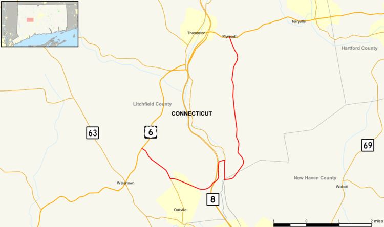
Route 262 is a state highway in west central Connecticut running in a "U" pattern from Watertown to Plymouth.
Contents
Map of CT-262, Connecticut, USA
Route description
Route 262 begins at an intersection with US 6 in Watertown. It heads southeast and east to Route 8, turning north and intersecting Route 8 at Exit 37 before crossing the Naugatuck River into Thomaston. In Thomaston, it continues south along the Naugatuck River to Waterbury. It briefly curves east just south of the Thomaston–Waterbury town line before turning north into Plymouth. In Plymouth, it heads north past the Waterbury Airport and Lake Plymouth before ending at another intersection with US 6.
History
Route 262 was commissioned in 1963 from South Street (old SR 862, which became a state road in 1959) and its southward continuation along Spruce Brook Road (which became state-maintained in 1962). It originally ran from Waterbury Road (modern SR 848) in Thomaston to US 6 in Plymouth. In 1964, with the opening of the Route 8 freeway from Waterbury to Thomaston, Route 262 was extended south along the former route of Route 8 to Huntingdon Avenue in Waterbury. In 1965, it was truncated back to Spruce Brook Road in Waterbury. In 1975, the Watertown section of Route 262 was added, using former SR 824 (newly constructed road from Buckingham Street to Frost Bridge Road in 1970) and SR 855 (Buckingham Street). In the same year, the section between Lake Plymouth and Tomlinson Road in Plymouth was realigned.