
Incorporated 1875 ZIP code 06778, 06787 Population 7,938 (2005) | NECTA Hartford Time zone Eastern (UTC-5) Elevation 136 m Local time Thursday 7:48 PM | |
 | ||
Region Central Naugatuck Valley Weather 8°C, Wind SE at 8 km/h, 37% Humidity Points of interest Mattatuck State Forest, Railroad Museum of New England, Nostalgia Tents & Amusements | ||
Thomaston is a town in Litchfield County, Connecticut, United States. The population was 7,503 at the 2000 census.
Contents
- Map of Thomaston CT USA
- History
- Geography
- Principal communities
- Adjacent towns
- Demographics
- Transportation
- Schools
- Landmarks
- Notable people
- References
Map of Thomaston, CT, USA
History
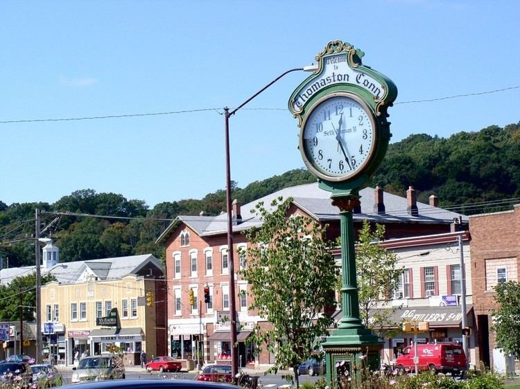
The town, originally part of Plymouth, Connecticut, and referred to as 'Plymouth Hollow' was first settled by Henry Cook ("the soldier in the wilderness," 1683–1750) around 1728. The town is known for clockmaking, which started in 1803, when Eli Terry established a factory in the town. Terry brought mass production to the clockmaking industry, helping to reduce the cost of clocks. He introduced and patented the shelf clock in 1814, which reduced the cost of a clock from $25 to $5. His clocks were sold throughout the US. It was incorporated in its own right and under the name "Thomaston" in 1875. The name derives from Seth Thomas, the early clockmaker, who established a factory in town in 1812. The Seth Thomas clock factory building still exists; however, the clockmaking industry has long since left the state as well as the country.
Geography
According to the United States Census Bureau, the town has a total size of 12.2 square miles (31.7 km²). 12.0 square miles (31.1 km²) of it is land and 0.2 square miles (0.6 km²) of it (1.80%) is water.
The town is located at the confluence of the Naugatuck River, Northfield Brook and Black Rock Brook, and is protected by Army Corps of Engineers flood control dams on each of these watercourses. These were all constructed in the years immediately following the devastating flood of 1955 which ravaged the town as well as the state in general.
Principal communities
Adjacent towns
Demographics
As of the census of 2000, there were 7,503 people, 2,916 households, and 2,067 families residing in the town. The population density was 624.7 people per square mile (241.2/km²). There were 3,014 housing units at an average density of 251.0 per square mile (96.9/km²). The racial makeup of the town was 97.85% White, Hispanic or Latino of any race were 1.45% of the population, 0.60% African American, 0.11% Native American, 0.49% Asian, 0.02% Pacific Islander, 0.41% from other races, and 0.53% from two or more races.
There were 2,916 households out of which 34.3% had children under the age of 18 living with them, 57.5% were married couples living together, 9.2% had a female householder with no husband present, and 29.1% were non-families. 24.0% of all households were made up of individuals and 9.7% had someone living alone who was 65 years of age or older. The average household size was 2.57 and the average family size was 3.07.
In the town, the population was spread out with 25.3% under the age of 18, 6.2% from 18 to 24, 33.2% from 25 to 44, 23.2% from 45 to 64, and 12.1% who were 65 years of age or older. The median age was 38 years. For every 100 females there were 97.2 males. For every 100 females age 18 and over, there were 94.8 males.
The median income for a household in the town was $54,297, and the median income for a family was $63,682. Males had a median income of $40,795 versus $31,744 for females. The per capita income for the town was $24,799. 4.2% of the population and 3.3% of families were below the poverty line. Of the total population, 5.8% of those under the age of 18 and 4.5% of those 65 and older were living below the poverty line.
Transportation
The Route 8 expressway runs along the Naugatuck River in the eastern part of town and has three exits in Thomaston. Other state highways in the town are Route 6, Route 109, Route 222, and Route 254. Thomaston is also headquarters of the Naugatuck Railroad, a heritage railway and short line freight operator that operates 21 miles (34 km) of former New Haven trackage between Waterbury and Torrington. Interchange is with Pan Am Railways at Highland Jct.
Schools
Thomaston is home to Thomaston High School, a school with roughly 300 students. It is also home to Black Rock Elementary School, hosting pre-K to 3rd grade, and Thomaston Center School, hosting the town's 4th, 5th, and 6th grade students.