
Country United States Status Operational Type of dam Concrete gravity Catchment area 3,499 km² | Purpose Flood control, power Opening date 1952 Height 44 m | |
 | ||
Owner United States Army Corps of Engineers Similar Roaring Run Trail, Keystone State Park, Blue Spruce Park, Laurel Caverns, Kiski Junction Railroad | ||
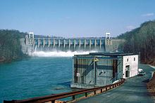
Conemaugh Dam (also known as Conemaugh River Dam or Conemaugh River Lake Dam) is a concrete gravity dam across the Conemaugh River, near the town of Saltsburg, in Pennsylvania. The dam was authorized by the Flood Control Act of 1936 and completed in 1952 by the U.S. Army Corps of Engineers for flood protection on the Conemaugh, Kiskiminetas, and Allegheny Rivers. The dam is one of 16 flood control structures in the Corps' Pittsburgh District.
Map of Conemaugh Dam, Clarksburg, PA 15725, USA
With a capacity of 355,000 acre feet (438,000 dam3), the lake is usually kept at a much lower level of 5,140 acre feet (6,340 dam3), to accommodate flash floods. Water is released as quickly as possible while not exacerbating flooding conditions downstream. The dam has prevented a total $2.2 billion of flooding-related damages between 1952 and 2013, including $375 million during Hurricane Ivan alone. The dam also supplies water to a 14 MW hydroelectric power station which was commissioned in 1989.
Conemaugh Lake National Recreation Area is located adjacent to the dam and preserves several historic sites, including segments of the Main Line Canal that once connected Pittsburgh to Philadelphia.