
Airport type Public 5/23 6,400 Code BAK Phone +1 812-376-2519 | Owner City of Columbus Elevation AMSL 656 ft / 200 m 6,400 1,951 Elevation 200 m | |
 | ||
Address 4770 Ray Boll Blvd, Columbus, IN 47203, USA Similar Otter Creek Golf Course, Blackerby's Hangar 5 Restaura, Atterbury Bakalar Museum, Columbus Visitors Center, CERAland Park | ||
Columbus Municipal Airport (IATA: CLU, ICAO: KBAK, FAA LID: BAK) is three miles north of Columbus, in Bartholomew County, Indiana, United States.
Contents
Most U.S. airports use the same three-letter location identifier for the FAA and IATA, but this airport is BAK to the FAA and CLU to the IATA.
History
The airport is on the site of the former World War II Atterbury Army Airfield, a U.S. Army Air Forces facility, and Bakalar Air Force Base, a U.S. Air Force installation utilized primarily by the Air Force Reserve. It was the host base for the 434th Troop Carrier Wing twice, from 1949-1952 and again from 1953-1969.
Facilities
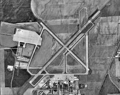
Columbus Municipal Airport covers 2,000 acres (810 ha) at an elevation of 656 feet (200 m). It has two concrete runways: 5/23 is 6,400 by 150 feet (1,951 x 46 m) and 14/32 is 5,000 by 100 feet (1,524 x 30 m).
In 2005 the airport had 39,155 aircraft operations, average 107 per day: 91% general aviation and 9% military. In 2015, 77 aircraft were based at the airport: 58 single-engine, 8 multi-engine, 7 jet, 2 helicopter, 1 glider and 1 ultra-light.
Terminal Building
The Airport completely redesigned its Terminal building in 2015.