
Country United States Time zone PST (UTC-8) Elevation 306 m Population 53,243 (2013) | Incorporated July 11, 1887 ZIP codes 92313, 92324 Local time Wednesday 4:18 PM Area code 909 | |
 | ||
Weather 27°C, Wind NW at 11 km/h, 19% Humidity | ||
Colton is a city in San Bernardino County, California, United States. Nickname:Hub City. The city is located in the Inland Empire region of the state and is approximately 57 miles east of Los Angeles. The population of Colton is 52,154 according to the 2010 census, up from 47,662 at the 2000 census.
Contents
- Map of Colton CA USA
- Geography
- Climate
- 2010
- 2000
- Government
- History
- Cemeteries
- Top employers
- Notable people
- References
Map of Colton, CA, USA
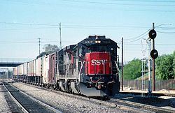
Colton is the site of Colton Crossing, which was one of the busiest at-grade railroad crossings in the United States. The crossing was installed in 1882 by the California Southern Railroad to cross the Southern Pacific Railroad tracks while building northward from San Diego. As a result of railroad acquisitions and mergers, this became the point at which the Burlington Northern Santa Fe's "Southern Transcontinental Route" crossed the Union Pacific's "Sunset Route". As traffic on each line began to soar in the mid-1990s, fueled largely by the vast increase in imports passing through the ports of Los Angeles and Long Beach, the primitive crossing became a serious bottleneck. On August 28, 2013, the at-grade crossing was officially replaced by a fly-over that raises the east–west UP tracks over the north–south BNSF tracks.
Geography
Colton is located at 34°3′54″N 117°19′18″W (34.064945, -117.321687).
According to the United States Census Bureau, the city has a total area of 16.0 square miles (41 km2). 15.3 square miles (40 km2) of it is land and 0.7 square miles (1.8 km2) of it (4.46%) is water.
Slover Mountain, once the highest point in San Bernardino County and the site of the Colton Liberty Flag, is located in the city.
Climate
According to the Köppen Climate Classification system, Colton has a warm-summer Mediterranean climate, abbreviated "Csa" on climate maps.
2010
The 2010 United States Census reported that Colton had a population of 52,154. The population density was 3,251.7 people per square mile (1,255.5/km²). The racial makeup of Colton was 22,613 (43.4%) White (13.0% Non-Hispanic White), 5,055 (9.7%) African American, 661 (1.3%) Native American, 2,590 (5.0%) Asian, 176 (0.3%) Pacific Islander, 18,413 (35.3%) from other races, and 2,646 (5.1%) from two or more races. Hispanic or Latino of any race were 37,039 persons (71.0%).
The Census reported that 51,824 people (99.4% of the population) lived in households, 85 (0.2%) lived in non-institutionalized group quarters, and 245 (0.5%) were institutionalized.
There were 14,971 households, out of which 7,826 (52.3%) had children under the age of 18 living in them, 7,167 (47.9%) were opposite-sex married couples living together, 3,233 (21.6%) had a female householder with no husband present, 1,340 (9.0%) had a male householder with no wife present. There were 1,268 (8.5%) unmarried opposite-sex partnerships, and 106 (0.7%) same-sex married couples or partnerships. 2,452 households (16.4%) were made up of individuals and 614 (4.1%) had someone living alone who was 65 years of age or older. The average household size was 3.46. There were 11,740 families (78.4% of all households); the average family size was 3.86.
The population was spread out with 16,671 people (32.0%) under the age of 18, 6,360 people (12.2%) aged 18 to 24, 14,965 people (28.7%) aged 25 to 44, 10,495 people (20.1%) aged 45 to 64, and 3,663 people (7.0%) who were 65 years of age or older. The median age was 28.4 years. For every 100 females there were 96.0 males. For every 100 females age 18 and over, there were 92.6 males.
There were 16,350 housing units at an average density of 1,019.4 per square mile (393.6/km²), of which 7,766 (51.9%) were owner-occupied, and 7,205 (48.1%) were occupied by renters. The homeowner vacancy rate was 2.6%; the rental vacancy rate was 9.2%. 28,063 people (53.8% of the population) lived in owner-occupied housing units and 23,761 people (45.6%) lived in rental housing units.
According to the 2010 United States Census, Colton had a median household income of $41,496, with 22.5% of the population living below the federal poverty line.
2000
As of the census of 2000, there were 47,690 people, 14,520 households, and 10,904 families residing in the city. The population density was 3,154.3 inhabitants per square mile (1,217.9/km²). There were 15,680 housing units at an average density of 1,037.7 per square mile (400.7/km²). The racial makeup of the city was 42.7% White, 11.0% African American, 1.3% Native American, 5.3% Asian, 0.2% Pacific Islander, 34.5% from other races, and 5.1% from two or more races. Hispanic or Latino of any race were 60.7% of the population.
There were 14,520 households out of which 46.5% had children under the age of 18 living with them, 48.3% were married couples living together, 19.5% had a female householder with no husband present, and 24.9% were non-families. 19.4% of all households were made up of individuals and 4.6% had someone living alone who was 65 years of age or older. The average household size was 3.3 and the average family size was 3.8.
In the city, the population was spread out with 34.9% under the age of 18, 11.9% from 18 to 24, 31.5% from 25 to 44, 15.2% from 45 to 64, and 6.4% who were 65 years of age or older. The median age was 27 years. For every 100 females there were 97.2 males. For every 100 females age 18 and over, there were 93.8 males.
The median income for a household in the city was $35,777, and the median income for a family was $37,911. Males had a median income of $32,152 versus $25,118 for females. The per capita income for the city was $13,460. About 18.2% of families and 19.6% of the population were below the poverty line, including 25.2% of those under age 18 and 10.9% of those age 65 or over.
Government
In the California State Legislature, Colton is in the 20th Senate District, represented by Democrat Connie Leyva, and in the 47th Assembly District, represented by Democrat Eloise Reyes.
In the United States House of Representatives, Colton is in California's 31st congressional district, represented by Democrat Pete Aguilar.
History
Colton was founded in 1875 and incorporated in 1887 but before its establishment, it was inhabited by the Serrano, Guachama, and San Gorgonio Indians. During the Mission Era the Mission San Gabriel established a Spanish settlement Politana in 1810, just northeast of what is now Colton. By 1840, Colton was part of two private ranchos, Jurupa and San Bernardino Rancho. From southwest area of modern-day Colton was known as "Agua Mansa" (Gentle Waters). It had been settled by New Mexico pioneers in 1842. What is currently known as Cooley Ranch was known as Indian Knolls for nearly 100 years. This is because the Indians living in what is now the San Bernardino Valley found refuge on the knolls of the property during the flood of 1862. The original owner of the property was George Cooley of Kent, England who had moved to Colton in 1853 and who purchased 200 acres at $3.50 an acre along the Santa Ana River the next year. Cooley was chairman of the San Bernardino County Board of Supervisors in San Bernardino County. By 1873, the property had mushroomed into a 400-acre property. Eventually, when property taxes had increased, the property was sold to Villelli Enterprises of La Habra. The city was named after David Douty Colton, who had been a Brigadier General of the California State Militia in 1855, prior to the Civil War. He was later the Vice President of the Southern Pacific Railroad Company.
Colton was created in its modern form when the Southern Pacific Railway was built heading east from Los Angeles in 1875.
Virgil Earp lived in Colton at 528 West “H” Street where he was the town’s first marshal. He resided in Colton from 1883 to 1889. Morgan Earp is buried at Hermosa Cemetery.
Cemeteries
The Hermosa Cemetery, also called the Hermosa Memorial Cemetery, is located on Meridian Street. Notable burials include MLB players Cam Carreon and Gordon Maltzberger, and Western lawman Morgan Earp.
The Montecito Memorial Park is located on East Washington Street. Notable burials include MLB players Dee Fondy, Freddie Fitzsimmons and Ken Hubbs, actress Lillian Miles, silent film star (and villain) Roy D'Arcy, and US Congressman Jerry Pettis.
Top employers
According to the City's 2010 Comprehensive Annual Financial Report, the top employers in the city are: