
Elevation 2,369 m | Topo map USGS Ross Dam Prominence 357 m | |
 | ||
First ascent July 31, 1931 by William Degenhardt and Herbert Strandberg Easiest route West Ridge: glacier/snow climb, scramble (class 3) Similar Snowfield Peak, Davis Peak, Jack Mountain, Mount Despair, Mount Terror | ||
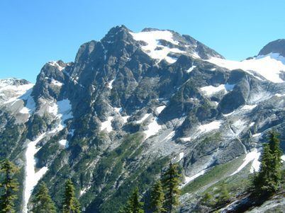
Colonial Peak is a mountain in the North Cascades of Washington, United States. It rises steeply from the southwest bank of Thunder Arm of Diablo Lake, one of the artificial reservoirs on the Skagit River. It is part of a group of peaks that form the northern end of a chain running south through prized climbing destinations such as Eldorado Peak, Forbidden Peak, and Goode Mountain. Colonial Peak takes its name from the Colonial mining claim on its slopes.
Map of Colonial Peak, Washington 98283, USA
Like many North Cascade peaks, Colonial Peak is more notable for its large, steep rise above local terrain than for its absolute elevation. For example, it rises 6,560 feet (2,000 m) above Thunder Arm in only 2.3 horizontal miles (3.7 km). Its rise over the Skagit river on the northwest is even greater, but not as steep.
Colonial Peak was first climbed on July 31, 1931 by William Degenhardt and Herbert Strandberg of the Seattle Mountaineers. The standard route is the West Ridge, accessed from Colonial Glacier; the approach is via the Pyramid Lake Trail, starting from near Diablo Dam on the North Cascades Highway.