
Population 1,383 (2006 census) Local time Thursday 7:56 AM | Postcode(s) 3315 Postal code 3315 | |
 | ||
Weather 19°C, Wind N at 14 km/h, 42% Humidity | ||
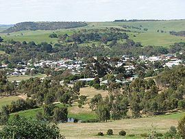
Coleraine is a town in Victoria, Australia on the Glenelg Highway, 350 kilometres (217 mi) west of the state capital, Melbourne and 35 kilometres (22 mi) north-west of Hamilton in the Shire of Southern Grampians local government area. It was named after the town in County Londonderry, Northern Ireland. At the 2006 census, the urban area of Coleraine had a population of 991.
Contents
Map of Coleraine VIC 3315, Australia
History
The area was first settled by Europeans in 1838 for pastoral grazing. The town was surveyed later on Bryan Creek, a tributary of the Wannon River. The Post Office opened on November 16, 1854. Today, Coleraine's primary industries are beef and wool. The town hosts an Autumn Festival in April and an art show in August.
Notable past residents of Coleraine include cosmetics manufacturer Helena Rubenstein.
Sport
Coleraine has a football team playing in the South West District Football League.
It has a horse racing club, the Coleraine Racing Club, which runs the Coleraine Cup meeting in September. The meeting features the steeplechase race commemorating the feats of district horsemen and renowned Australian poet Adam Lindsay Gordon.
Golfers play at the Coleraine Golf Club on Gordon Street.