
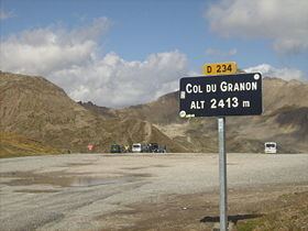
Traversed by D234T Elevation 2,413 m | ||
 | ||
Similar Alps, Col d'Izoard, Col du Lautaret, Col de l'Échelle, Col du Galibier | ||
Col du granon tour de france 1986 stage 17
Col du Granon (el. 2,413 m or 7,917 ft) is a high mountain pass in the Alps in the department of Hautes-Alpes in France. A narrow tarmac road winds steeply up the southern approach. Gravel roads continue beyond the pass, in a military training zone.It hosted the highest ever mountain-top stage finish in the Tour de France—once only—in 1986, until the 2011 Tour de France, that had a finish in the Col du Galibier, at 2,645 m (8,678 ft) of altitude. Eduardo Chozas of Spain won the stage after a long lone breakaway.
Contents
- Col du granon tour de france 1986 stage 17
- Map of Col du Granon 05100 Val des PrC3A9s France
- Col du granon
- Description
- References
Map of Col du Granon, 05100 Val-des-Pr%C3%A9s, France
Col du granon
Description
Two roads lead to the pass at 2,645 m (8,678 ft). The D234T climbs 11.5 kilometres (7.1 mi) with a 9% average gradient from Saint-Chaffrey at an altitude of 1,364 metres (4,475 ft). From the east a dirt road to the military pass at Val-des-Prés climbs 15.3 kilometres (9.5 mi) at almost 7% gradient.