
Traversed by D294 | Elevation 1,035 m | |
 | ||
Similar Col d'Aubisque, Col du Soulor, Col de Peyresourde, Col d'Aspin, Col du Pourtalet | ||
Marcha cicloturista quebrantahuesos spain col de marie blanque
Col de Marie-Blanque (elevation 1,035 m (3,396 ft)) is a mountain pass in the western Pyrenees in the department of Pyrénées-Atlantiques in France. The pass is situated south-east of Oloron-Sainte-Marie and connects the valleys of the Aspe and the Ossau rivers.
Contents
- Marcha cicloturista quebrantahuesos spain col de marie blanque
- Map of Col de Marie Blanque 64260 BilhC3A8res France
- Panic on the col de marie blanque
- Details of the climb
- Tour de France
- References
Map of Col de Marie-Blanque, 64260 Bilh%C3%A8res, France
Panic on the col de marie blanque
Details of the climb
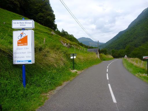
The western side of the climb, starts from Escot on the N134. The climb is 9.3 km (5.8 mi) long at an average gradient of 7.7% (height gain – 715 m (2,346 ft)). Although relatively short, there are several long sections with gradients in excess of 11%.
From Louvie-Juzon (east), the climb is 15.0 km (9.3 mi) long. Over this distance, it gains 615 m (2,018 ft) at an average gradient of 4.1%. The climb proper starts at Bielle on the D934 from where it is 11.5 km (7.1 mi) long, gaining 585 m (1,919 ft) at an average gradient of 5.1%, with a maximum of 8.5% near the start. En route, the climb passes the Plateau de Bénou.
Tour de France
The pass was first used in the Tour de France in 1978 and has been crossed 14 times by the tour, including on stage 17 of the 2010 tour from Pau to the Col du Tourmalet.