
Elevation 1691 m | Traversed by D354 road | |
 | ||
Similar Col de la Colombière, Alps, Col de la Ramaz, Col de la Joux Verte, Col des Aravis | ||
Col de joux plane samo ns cycling inspiration education
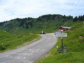
Col de Joux Plane (el. 1691 m.) is a high mountain pass in the Alps in Haute-Savoie, France, linking Morzine with Samoëns. The climb has been featured several times in the Tour de France cycling race
Contents
- Col de joux plane samo ns cycling inspiration education
- Map of Col de Joux Plane 74440 Verchaix France
- Epic descent col de joux plane
- Climb details
- Tour de France
- References
Map of Col de Joux Plane, 74440 Verchaix, France
Epic descent col de joux plane
Climb details
Tour de France
Col de Joux Plane has been used a total of 12 times by the Tour de France since its debut in 1978.
References
Col de Joux Plane Wikipedia(Text) CC BY-SA