
Demonym(s) Cogoletesi Province Province of Genoa | Elevation 4 m (13 ft) Local time Wednesday 12:51 PM Postal code 16016 | |
 | ||
Frazioni Lerca, Sciarborasca, Pratozanino Weather 17°C, Wind N at 13 km/h, 19% Humidity Points of interest Bagni Mauro, Trincee tedesche, Lungomare Europa Cogoleto | ||
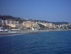
Cogoleto is a comune (municipality) in the Metropolitan City of Genoa in the Italian region Liguria, located about 25 kilometres (16 mi) west of Genoa. Its territory extends from the sea to the Ligurian Apennines; it is part of the Natural Regional Park of Monte Beigua.
Contents
Map of 16016 Cogoleto Genoa, Italy
History
The area of Cogoleto is identified in the Roman Peutingerian Table as Hasta, with a bridge (destroyed in World War II by Allied bombings) existing here. The first mention of the town dates to 1039, and in 1091 it was included in Bonifacio del Vasto's Marquisate of Savona. In 1343 it was acquired by the Republic of Genoa.
On April 11, 1800 it was the seat of a battle between the French and Austrian armies. Cogoleto became part of the Kingdom of Sardinia in 1815, following its history in the unification of Italy and modern Italian history.
Main sights
Twin towns
Nature conservtion
Part of the municipality territory is within the boundaries of the Parco naturale regionale del Beigua.