
Prominence 815 First ascent ancestral Province Province of Savona | Parent range Ligurian Apennines Elevation 1,287 m Mountain range Apennine Mountains | |
 | ||
Similar Monte Reixa, Monte Rama, Monte Sciguello, Monte Argentea, Monte Antola | ||
Salita al monte beigua e discesa al colle del giovo in mtb
Monte Beigua (also in Ligurian: Monte Peigoa) is a mountain in the Ligurian Apennines in Liguria, northern Italy, between the two communes of Varazze and Sassello.
Contents
- Salita al monte beigua e discesa al colle del giovo in mtb
- Map of Monte Beigua 17044 Stella Province of Savona Italy
- Vista sul monte beigua la riviera ligure di ponente
- Geography
- History
- Nature conservation
- References
Map of Monte Beigua, 17044 Stella Province of Savona, Italy
Vista sul monte beigua la riviera ligure di ponente
Geography
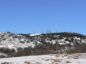
The mountain, at 1,287 m, is the highest peak in the so-called Gruppo del Beigua including Monte Grosso (1,265 m), Monte Ermetta (1,267 m) and Bric Veciri (1,263). The upper part of the mount houses transmission antennas used by RAI (Italian state television) and other private networks.
History
It has been hypothized that it was a sacred mountain to the Liguri tribe living here in pre-Roman times, together with the Mont Bégo and Monte Sagro.
Nature conservation
It is included in the eponymous Regional Park.
References
Monte Beigua Wikipedia(Text) CC BY-SA