
Country Netherlands Demonym(s) Coevordenaar Postcode 7740–7759, 7840–7869 Area 299.7 km² Local time Wednesday 11:27 AM | Elevation 12 m (39 ft) Time zone CET (UTC+1) Area code 0524, 0528, 0591 | |
 | ||
Weather 6°C, Wind S at 26 km/h, 87% Humidity | ||
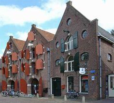
Coevorden the netherlands
Coevorden ( [ˈkuvɔrdən]; Dutch Low Saxon: Koevern) is a municipality and a city in the northeastern Netherlands. During the municipal reorganisation in the province in 1998, Coevorden merged with Dalen, Sleen, Oosterhesselen and Zweeloo.
Contents
- Coevorden the netherlands
- Map of Coevorden Netherlands
- Etymology
- History
- Geography
- International relations
- Transportation
- References
Map of Coevorden, Netherlands
Etymology
The name Coevorden means "cow ford(s)" or "cow crossing", similar to Bosporus or Oxford.
History
Coevorden received city rights in 1408.
The city was captured from the Spanish in 1592 by a Dutch and English force under the command of Maurice, Prince of Orange. Coevorden was then reconstructed in the early seventeenth century to an ideal city design, similar to Palmanova. The streets were laid out in a radial pattern within polygonal fortifications and extensive outer earthworks.
The city of Coevorden may have indirectly given its name to the city of Vancouver, which is named after the 18th-century British explorer George Vancouver. The explorer's ancestors (and family name) may have originally come to England "from Coevorden" (van Coevorden > Vancoevorden > Vancouver). There is also a family of nobility with the surname van Coeverden, sometimes spelled with a K (as with Canadian kayaker Adam van Koeverden).
Geography
Coervorden is located at 52°40′N 6°45′E in the south of the province of Drenthe in the east of the Netherlands.
The population centres in the municipality are:
International relations
Coevorden is twinned with:
Transportation
There is one railway station in the municipality: