Population 99 Civil parish Coddington Dialling code 01531 | OS grid reference SO719427 Unitary authority | |
 | ||
Coddington is a hamlet and civil parish in eastern Herefordshire, England, approximately 3 miles (4.8 km) north of Ledbury. The west side of the parish falls within the Malvern Hills AONB. Coddington shares a parish council with neighbouring Bosbury.
Contents
Map of Coddington, Ledbury, UK
Geography
The parish is small in area and population, with dispersed small settlements and farms. The church and surrounding hamlet (of Coddington) is situated on a shallow hill, which rises to 110 metres (360 ft). The highest point in the parish is Oyster Hill at 211 metres (692 ft), which has an Ordnance Survey triangulation station. Further places in the parish include Coddington Cross (at a crossroads on the main road through the parish, which does not pass through the hamlet of Coddington), Bush Farm, Pithouse Farm, Coddington Court, and Woofields Farm.
The nearest railway stations are Ledbury and Colwall, both about 3.5 miles (5.6 km) away by road. The Herefordshire Trail, a long-distance footpath, passes through the parish, calling at the vineyard, the church and Oyster Hill.
History
Coddington was recorded as a manor in the Domesday Book (1086), then spelled as Cotingtune; the manor was held by the Bishop of Hereford.
The Ordnance Survey map of 1887 shows a school and a post office in the hamlet. It also shows two public houses (the Plough Inn and the Golden Cross Inn) on the lane between Coddington Court and Coddington Cross. All these amenities have now closed.
It was the birthplace of Lionel George Curtis, a prominent advocate of world government. It was home to one of the few independent British oil companies, established in the 1970s by a group of ex-Royal Dutch Shell employees – Clyde Petroleum.
The parish features many listed buildings, including many black and white half-timbered cottages and houses, one of which is Grade II* (Bush Farm).
Religion
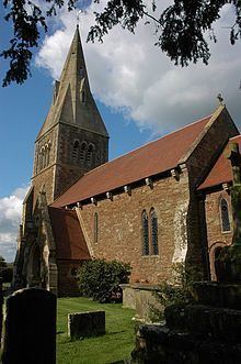
The Church of England parish church of All Saints is a Grade II* listed building largely of 12th and 13th century construction, which features a broach spire; it today shares services with nearby Colwall. In the churchyard is a Grade II* listed cross, the base of which dates to the 14th century.
There is a Buddhist retreat and study centre at Coddington Court. It includes the residence of Sangharakshita, the London-born founder of the Triratna Buddhist Community.
Demographics
According to the 2001 census Coddington had a population of 108, whilst the two parishes of Bosbury and Coddington had a combined population of 888, decreasing 8.5% to 813 at the 2011 census, giving an estimated population for Coddington of 99.
Politics
Coddington (two seats) shares a parish council with a larger neighbour, Bosbury (eleven seats). They and the parishes of Colwall and Mathon form the ward of Hope End, which elects one member to Herefordshire Council. At the most recent election in May 2015, the Conservative candidate, Tony Johnson, won the seat. He has since been elected Leader of the Council. Coddington lies in the North Herefordshire parliamentary constituency, represented by Bill Wiggin (Conservative).
