Topo map OSI Discovery 78 Prominence 253 m Easiest route Hiking Listing Marilyn | OSI/OSNI grid V835841 Elevation 988 m Mountain range Macgillycuddy's Reeks Parent range Macgillycuddy's Reeks | |
 | ||
Similar Cruach Mhór, Maolán Buí, The Big Gun, Caher West Top, The Bones | ||
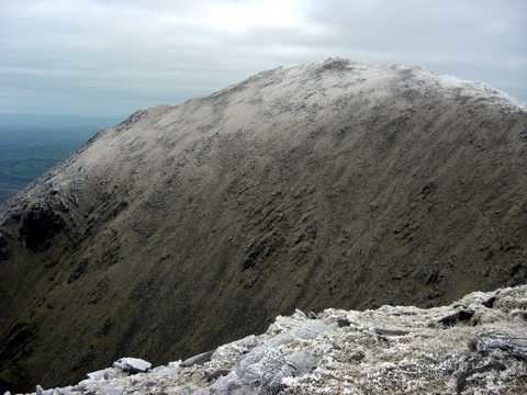
Cnoc na Péiste—often anglicised as Knocknapeasta and more rarely given as Slievenapeesta or Cummeennapeasta—is a 988 m (3,241 ft) mountain peak in County Kerry, Ireland. It is part of the Macgillycuddy's Reeks range and is the fourth highest summit in Ireland—after Carrauntoohil, Beenkeragh and Caher; which are also part of the range. It is classed as a Furth by the Scottish Mountaineering Club, which is why it is also sometimes referred to as one of the Irish Munros.
Contents
- Map of Cnoc na Peiste Derrycarna Co Kerry Ireland
- Surroundings
- Aircraft crash
- Climbing Cnoc na Piste
- References
Map of Cnoc na Peiste, Derrycarna, Co. Kerry, Ireland
Surroundings
Cnoc na Péiste is the highest point on a ridge heading east from Carrauntoohil towards Purple Mountain, from which it is separated by the Gap of Dunloe. To the southwest of Cnoc na Péiste is the peak of Maolán Buí (973 m) and to the northeast is An Gunna Mhór (939 m) or "The Big Gun".
Between Cnoc na Péiste and An Gunna Mhór there are two small lakes—Loch Coimín Piast (anglicised Lough Cummeenapeasta) and Lough Googh — one on either side of the ridge. A stream called Glasheencummeennapeasta flows northwards from Lough Cummeenapeasta into Hag's Glen, where it joins the Gaddagh River. On the other side of the ridge, a stream flows southwards from Lough Googh into the Derrycarna River.
Aircraft crash
At about 7 am on 17 December 1943, during World War II, a United States Army Air Forces (USAAF) plane crashed into the side of Cnoc na Péiste. The plane was a Douglas C-47 or Dakota (serial number 43-30719) with five crewmen aboard. It struck the mountain just above Lough Cummeenapeasta at an altitude of about 2,000 ft—killing all five passengers. The Gardaí were not alerted to the crash until 3 February 1944, and the following day an Irish Army detachment was sent to recover the bodies. Pieces of the aircraft can still be seen on the mountainside, and a plaque was placed at the shore of the lake to commemorate the victims.
Climbing Cnoc na Péiste
Climbers and walkers tend to tackle all the Macgillycuddy's Reeks in a single attempt, often from the north-east along the Hag's Glen, since there are few other options for descent from the main ridge. The continuation of the ridge east of Cnoc na Péiste is very sharp and cannot be walked; hikers must take a route to one side of the ridge to continue on to An Gunna Mhór.
