
Country United States County Oakland ZIP codes 48017, 48398 Area 5.7 km² Population 12,048 (2013) Area code 248 | Time zone EST (UTC-5) FIPS code 26-16160 Elevation 202 m Local time Monday 4:28 PM | |
 | ||
Weather 13°C, Wind S at 16 km/h, 76% Humidity University Academy of Court Reporting-Clawson | ||
Clawson is a city in Oakland County in the U.S. state of Michigan. It is part of the Detroit metropolitan area. As of the 2010 census, its population was 11,825.
Contents
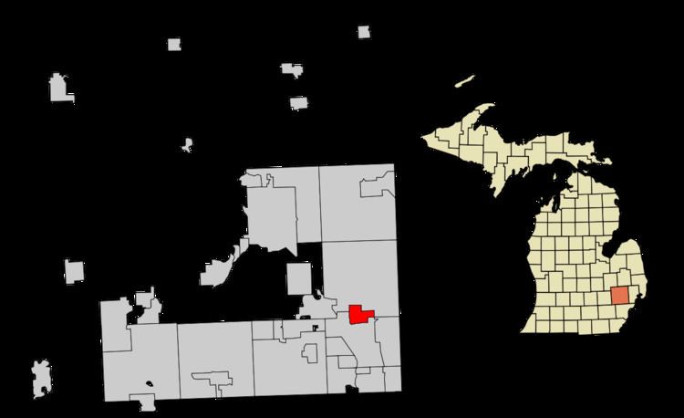
- Map of Clawson MI USA
- History
- Geography
- 2010 census
- 2000 census
- Government
- Education
- Notable people
- References
Map of Clawson, MI, USA
History
The city's name is a misspelling of John Lawson's name, a local settler. Clawson began in 1829 and was originally known as Pumachug and The Corners. It was incorporated in 1921 as a village and in 1940 as a city.
Geography
According to the United States Census Bureau, the city has a total area of 2.20 square miles (5.70 km2), all land.
2010 census
As of the census of 2010, there were 11,825 people, 5,460 households, and 2,992 families residing in the city. The population density was 5,375.0 inhabitants per square mile (2,075.3/km2). There were 5,791 housing units at an average density of 2,632.3 per square mile (1,016.3/km2). The racial makeup of the city was 93.4% White, 1.9% African American, 0.3% Native American, 2.0% Asian, 0.4% from other races, and 1.9% from two or more races. Hispanic or Latino of any race were 2.1% of the population.
There were 5,460 households of which 23.5% had children under the age of 18 living with them, 41.8% were married couples living together, 8.9% had a female householder with no husband present, 4.1% had a male householder with no wife present, and 45.2% were non-families. 38.2% of all households were made up of individuals and 11.8% had someone living alone who was 65 years of age or older. The average household size was 2.14 and the average family size was 2.88.
The median age in the city was 39.9 years. 17.9% of residents were under the age of 18; 7.6% were between the ages of 18 and 24; 31.4% were from 25 to 44; 28.4% were from 45 to 64; and 14.8% were 65 years of age or older. The gender makeup of the city was 49.0% male and 51.0% female.
2000 census
As of the census of 2000, there were 12,732 people, 5,572 households, and 3,259 families residing in the city. The population density was 5,787.0 people per square mile (2,234.5/km²). There were 5,676 housing units at an average density of 2,579.9 per square mile (996.1/km²). The racial makeup of the city was 96.10% White, 0.80% African American, 0.34% Native American, 1.32% Asian, 0.25% from other races, and 1.19% from two or more races. Hispanic and Latino of any race were 1.14% of the population.
There were 5,572 households out of which 25.1% had children under the age of 18 living with them, 46.8% were married couples living together, 8.9% had a female householder with no husband present, and 41.5% were non-families. 35.2% of all households were made up of individuals and 12.5% had someone living alone who was 65 years of age or older. The average household size was 2.26 and the average family size was 2.98.
In the city, the population was spread out with 20.6% under the age of 18, 7.5% from 18 to 24, 34.8% from 25 to 44, 21.9% from 45 to 64, and 15.2% who were 65 years of age or older. The median age was 38 years. For every 100 females there were 94.0 males. For every 100 females age 18 and over, there were 89.5 males.
The median income for a household in the city was $50,929, and the median income for a family was $64,684. Males had a median income of $45,242 versus $30,679 for females. The per capita income for the city was $25,676. About 1.4% of families and 3.5% of the population were below the poverty line, including 1.6% of those under age 18 and 4.8% of those age 65 or over.
Government
Clawson utilizes the Council-Manager form of government, and thus is governed by a City Council consisting of a Mayor and four council members. The city council appoints a City Manager, who manages the day-to-day operations of the city.
Clawson is represented in the State House of Representatives by Martin Howrylak, in the State Senate by Marty Knollenberg, in the US Congress 9th Congressional District by Sander M. Levin, and in the US Congress 11th Congressional District by David Trott.
Education
In the city of Clawson, there are three separate public educational facilities operated by Clawson Public Schools. The two elementary schools are Paul A. Schalm Elementary (in the northwestern section of the city) and Kenwood Elementary (in the southwest). Clawson High School and Clawson Middle School are linked and share some common facilities. Additionally, Baker serves as the preschool and administrative building.
Schalm Elementary serves children through fifth grade living north of 14 Mile Road and/or west of Rochester. Kenwood serves those south of 14 Mile and/or east of Rochester. There is a bus service for any child who has to cross more than one of those roads. For those children who are required to cross one of the roads there are crossing guards at specific corners. The middle school and high school do not have any busing.
Japhet School, a private school, is located in a former YWCA building in Clawson. It moved there in August 2013 from its previous location in Madison Heights.