
Population 145,822 (2015 est) Area 36 km² | Mayor Noel D'Souza (Labor) Region Metropolitan Sydney Local time Monday 4:23 PM | |
 | ||
State electorate(s) CoogeeMaroubraHeffron Weather 23°C, Wind S at 47 km/h, 60% Humidity Points of interest | ||
The City of Randwick is a local government area in the eastern suburbs of Sydney, New South Wales, Australia.
Contents
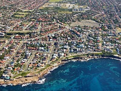
- Map of Randwick NSW Australia
- Suburbs and localities in the local government area
- Demographics
- Current composition and election method
- History
- Proposed amalgamation
- References
Map of Randwick, NSW, Australia
One of Sydney's largest parks, Centennial Park, lies within the city boundary of Randwick. Other major landmarks in Randwick include the world-famous Randwick Racecourse, the University of New South Wales and Coogee and Maroubra beaches. There is some industry in the south, centered on the container terminals of Port Botany in Botany Bay, which lie partially within the city. Randwick has several golf clubs, including the exclusive Australian and New South Wales golf clubs.
Major commercial centres within Randwick City include the suburb of Randwick, home to the municipal council; Kingsford, which has a large Chinese and Indonesian community, as well as a large student population; Maroubra Junction; and Matraville. The Australian Army has a major presence in Randwick, with the headquarters of the 2nd Division being located in Randwick Barracks, Avoca Street, Randwick. There is a large state prison at Long Bay (Long Bay Correctional Centre). The Prince of Wales Hospitals, adjacent to the University of New South Wales, is one of Sydney's major hospital complexes. The Botany Bay National Park lies partially within the City of Randwick and is notable for preserving some of the last remaining stands of pre-European coastal heath vegetation in the Sydney area, known as Endangered Eastern Suburbs Banksia Scrub. There is a historic fort on Bare Island at the mouth of Botany Bay, in the suburb of La Perouse. This fort, and another Randwick attraction, the racecourse, featured prominently in the 2000 movie Mission: Impossible II. La Perouse is also home to one of Sydney's largest indigenous Australian communities.
The Mayor of the City of Randwick is Cr. Noel D'Souza, a member of the Labor Party.
Suburbs and localities in the local government area
Suburbs and localities in the City of Randwick are:
These localities are also serviced by Randwick Council:
Demographics
At the 2011 census, there were 128,989 people in the Randwick local government area, of these 49.1% were male and 50.9% were female. Aboriginal and Torres Strait Islander people made up 1.4% of the population. The median age of people in the City of Randwick was 35 years. Children aged 0-14 years made up 15.1% of the population and people aged 65 years and over made up 13.1% of the population. Of people in the area aged 15 years and over, 40.0% were married and 9.4% were either divorced or separated.
Population growth in the City of Randwick between the 2001 Census and the 2006 census was 1.10%; and in the subsequent five years to the 2011 census, population growth was 7.59%. When compared with total population growth of Australia for the same periods, being 5.78% and 8.32% respectively, population growth in Randwick local government area was lower than the national average. The median weekly income for residents within the City of Randwick was higher than the national average.
Current composition and election method
Randwick City Council is composed of fifteen Councillors elected proportionally as five separate wards, each electing three Councillors. All Councillors are elected for a fixed four-year term of office. The Mayor is elected by the Councillors at the first meeting of the Council. The most recent election was held on 8 September 2012, and the makeup of the Council is as follows:
The current Council, elected in 2012, in order of election by ward, is:
History
Indigenous Australian history in the area dates back tens of thousands of years. The local people at the time of colonisation were the Cadigal of the Dharug language group. European settlement led to the deaths of many Cadigal via introduced diseases or in conflict with settlers. The surviving Cadigal left the area or were pushed to the fringes of settlement. By the mid-nineteenth century, the original tribal groupings had been effectively destroyed.
The name Randwick comes from the village of Randwick in Gloucestershire, England, birthplace of the district's first mayor Simeon Henry Pearce. The area was home to a few wealthy landowners and the poor residents of several shantytowns until the 1880s, when the coming of trams from Sydney brought extensive suburban development. This development continued steadily, with new tram lines (long since demolished) opening up most of the city for subdivision by the early 1900s.
The New South Wales University of Technology opened at Kensington in 1949 on the site of Kensington Racecourse, eventually becoming the University of New South Wales. The university is now one of Randwick City's major landmarks.
The City of Randwick now has a significant indigenous Australian population, mostly concentrated in the southern half of the city.
Proposed amalgamation
A 2015 review of local government boundaries recommended that the City of Randwick merge with the Waverley and Woollahra councils to form a new council with an area of 58 square kilometres (22 sq mi) and support a population of approximately 274,000. Following an independent review, in May 2016 the NSW Government sought to dismiss the Council and force its amalgamation with Woollahra and Waverley councils. Woollahra Council instigated legal action claiming that there was procedural unfairness and that a KPMG report at the centre of merger proposals had been "misleading". The matter was heard before the NSW Court of Appeal who, in December 2016, unanimously dismissed Woollahra Council's appeal, finding no merit in its arguments that the proposed merger with Waverley and Randwick councils was invalid.