
Population 31,500 (1992) Area 9.71 km² | Established 1860 Founded 1860 | |
 | ||
City of hawthorn centenary 1860 1960 grand parade
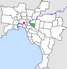
The City of Hawthorn was a local government area about 4 kilometres (2.5 mi) east of Melbourne, the state capital of Victoria, Australia, on the southeast bank of the Yarra River. The city covered an area of 9.71 square kilometres (3.75 sq mi), and existed from 1860 until 1994.
Contents
- City of hawthorn centenary 1860 1960 grand parade
- Angie reyes english council memeber city of hawthorn
- History
- Wards
- Geography
- Population
- References
Angie reyes english council memeber city of hawthorn
History
Hawthorn was incorporated as a municipal district on 27 July 1860. It was proclaimed as a town on 18 March 1887, and a city on 12 September 1890.
On 22 June 1994, the City of Hawthorn was abolished, and, along with the Cities of Camberwell and Kew, was merged into the newly created City of Boroondara.
The council met at the Hawthorn Town Hall, at the corner of Burwood and Glenferrie Roads, near Glenferrie railway station, Hawthorn. The facility is still used by the City of Boroondara as a regional arts centre.
Wards
The City of Hawthorn was divided into four wards on 1 October 1923, each electing three councillors:
Geography
The council area covered the suburbs of Hawthorn, Hawthorn East and parts of Glen Iris, and was bounded by the Yarra River to the west, Barkers Road to the north, Gardeners Creek and CityLink (formerly South Eastern Freeway) to the south and Burke Road to the east.
Population
* Estimate in the 1958 Victorian Year Book.