
Prominence 1,521 m (4,990 ft) Elevation 3,173 m Province Trentino Listing Ultra-prominent peak | Easiest route Via Normale First ascent 20 July 1865 | |
 | ||
Similar Cima Brenta, Crozzon di Brenta, Campanile Basso, Cima d’Ambiéz, Cima Brenta Alta | ||
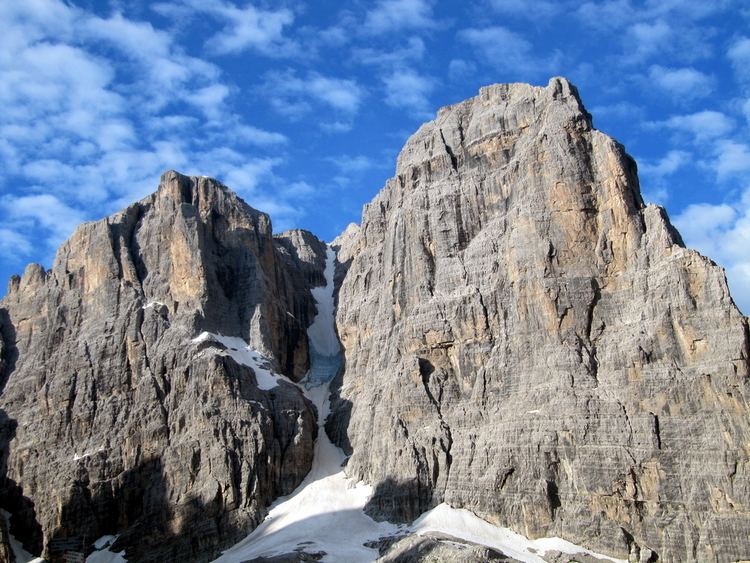
Cima Tosa is a mountain in the Brenta group (It.: Dolomiti di Brenta), a subgroup of the Rhaetian Alps in the Italian Region of Trentino-Alto Adige, with a reported height of (3,173 metres (10,410 ft)) With this elevation, the prominence of Cima Tosa would amount up to 1,521 meters above the reference point at Passo Carlo Magno near Madonna di Campiglio at 1,652 meters. Cima Tosa therefore qualifies as one of Europe's ultra prominent peaks. The mountain rises up above Val Rendena with its 800 meters vertical north face with a steep couloir called Canalone della Tosa dividing it from its dazzling ante-peak Crozzon di Brenta. The summit is topped by a snow cupola above the rock face, almost like a shaven head, hence the name Cima Tosa (Iocal dialect: Shaven Summit). The south-eastern side descends in a series of snowy terraces and vertical rock pillars.
Contents
- Map of Cima Tosa 38078 San Lorenzo in Banale Province of Trento Italy
- Height and prominenceEdit
- Climbing historyEdit
- ViewsEdit
- References
Map of Cima Tosa, 38078 San Lorenzo in Banale, Province of Trento, Italy
Height and prominenceEdit
Cima Tosa's reported elevation is 3,173 meters. With this elevation, it is the Brenta Group's highest point and the 38th alpine ultra-prominent peak. The height of Cima Tosa was determined by triangulation measurement under Austro-Hungarian rule and later in the 1930s. If done correctly, a correction should have been applied that would have deducted the thickness of the snow cover. In the case of Cima Tosa summit, where the snow forms its characteristic snow dome, that layer of snow may have been substantial and difficult to measure. Recent amateur research has suggested that Cima Tosa is not as high as 3,173 meters and might even be lower than Cima Brenta. Due to global warming, the summit snow dome would have shrunk some 20 meters in height, explaining an allegedly consistent GPS-reading of around 3,150 meters on the top of Cima Tosa. Undoubtedly, the snow/ice cap on Cima Tosa has suffered from the effects of climate change as much as the glaciers ("vedrette") surrounding the Cima Tosa massif. The thickness of the snow layer should, however, have been ruled out as a matter of routine, in the triangulation surveys that were done around the turn of the century and confirmed by later official surveys. The issue of reliability of GPS elevation readings possibly plays a role in the recent deviating measurements. Elevation error in GPS use is, as a rule, considerably worse than the horizontal position error. In the end, regardless of climate change and pending further official investigation, Cima Tosa might still be considered Brenta's highest and a genuine European ultra prominent peak.
Climbing historyEdit
The first men to undertake the ascent were Giuseppe Loss, a botanist and alpinism pioneer from Primiero, together with six companions. On July 18, 1865 they departed from San Lorenzo in Banale, advanced through Val d'Ambiez and having passed over the Forcolotta di Noghera approached the mountain over the vedretta d'Ambiez through the south-east slope along the trajectory that constitutes what is now known as the 'Via Normale'. Cima Tosa turned out to be accessible only by climbing through a 25-metre drop vertical rock face. They decided to climb through a wet chimney, 'il camino della Tosa', (UIAA: II) though one of the companions thought it better to stay behind. Finally they reached the top, and by doing so, they preceded an undertaking of the founder of the Alpine Club (UK), John Ball, by just four days. John Ball's account of his ascent in the 'Alpine Journal' brought the mountain into the alpinists' limelight. Loss' and Ball's itinerary would remain the only way for a number of years, while several attempts were made to reach the three consecutive summits of Crozzon di Brenta passing over the ridge between the two mountains. A new itinerary to the summit of Cima Tosa from the south was found in 1886 by A. Migotti (Via Migotti, I/II). The local guides, notably the Nicolussi brothers from Molveno and Antonio Dallagiacomo from Madonna di Campiglio, accompanied most of the early explorers and daring wealthy tourists to the summit of this mountain and beyond to the summits of Crozzon. The guide Enrico Giordano from Molveno accompanied the Italian novelist and poet Antonio Fogazzaro to the summit of Cima Tosa in 1890. Fogazzaro expressed his impressions on the mountain in the poem "Il Pianto della Tosa". Carlo Garbari and Nino Pooli traced a new route through the eastern rock face in 1890 (200m: II). In 1911, Giovanni Battista 'Tita' Piaz -il diavolo delle Dolomiti- and Michelson climbed through the majestic north-east face for the first time. Daredevil Piaz initially considered his 'Via Piaz' (IV+/V) itinerary too risky to be attempted again. But it would be repeated by Virgilio Neri, the same man that solo-climbed in 1929 the 'Canalone della Tosa', the glaciered couloir that descends almost vertical from the top of Cima Tosa through the north face - the classic ice-climb of the Dolomites. Neri repeated the Via Piaz in 1930 together with Mario Agostini. During the next decades another number of classical climbing routes was opened: Via Diretta (E wall) - 750m - IV/V (1933, Bruno Detassis, Ettore Castiglione), Via Barbier (NE wall) - 750 m - IV+ (1965), Via Flli. Detassis (NE wall) - 700 m - V (1962), Via Città di Brescia - (SW wall) - 350m - V/VI- (1962, Armando Aste, Franco Solina) Via Maestri(E wall) - 350m - IV (1975). Many other interesting climbing itineraries and variants are available on all sides of this mountain. The classic routes of Crozzon di Brenta, essentially a pre-summit of Cima Tosa, are available at very short distance.
ViewsEdit
Lake Garda is brightly visible on a clear day. Towards the north the summits and pinnacles of the central Brenta Group are all looked upon from above. Westwards a complete view of the Adamello and Presanella, while right under the snow field disappears into the Canalone della Tosa. This couloir was descended on ski's the first time in 1970 by Heini Holzer and A. Tscholl and has become a classic for those engaged in extreme skiing.