
Easiest route from Passo Frontè Prominence 60 m | First ascent ancestral Elevation 2,141 m | |
 | ||
Similar Monte Frontè, Rocca delle Penne, Monte Galero, Monte Saccarello, Bric Gettina | ||
Prima slavina da cima garlenda im
Cima Garlenda is a 2141 m mountain of the Ligurian Alps, in Italy. After Monte Saccarello and Monte Frontè it is the third Ligurian summit.
Contents
- Prima slavina da cima garlenda im
- Cima garlenda
- GeographyEdit
- HistoryEdit
- Access to the summitEdit
- Mountain hutsEdit
- ConservationEdit
- References
Cima garlenda
GeographyEdit
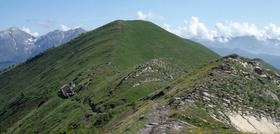
The mountain is located in the province of Imperia, in Liguria. In the SOIUSA (International Standardized Mountain Subdivision of the Alps) it belongs to the Nodo del Monte Saccarello (SOIUSA code: I/A-1.II-A.1.a). Cima Garlenda is located on the main chain of the Alps between Tanaro and Arroscia valleys, and is divided from the neighbouring Monte Frontè by Passo Frontè (2081 m).
HistoryEdit
The slopes of Cima Garlenda were deforested during past centuries in order to increase pasturess land. The lower part of the mountain was mainly used by cattle while is upper part was mainly grazed by sheep and goats. The slopes of the mountain belonging to Arroscia Valley are still used for grazing.
Access to the summitEdit
The summit of Cima Garlenda can easily be accessed following an unmarked trak starting from passo Frontè, which is accessible by the Alta Via dei Monti Liguri, a long-distance trail from Ventimiglia (province of Imperia) to Bolano (province of La Spezia). its whide summit ca also be accessed by mountain bike.
Mountain hutsEdit
ConservationEdit
The southern side of the mountain since 2007 is included in the Parco naturale regionale delle Alpi Liguri.