
Discharge 1,620 m³/s Mouth Atlantic Ocean | Length 856 km Source elevation 1,550 m Country Canada | |
 | ||
Native name (Grand River, Mishtashipu) Basin size 79,800 km (30,800 sq mi) | ||
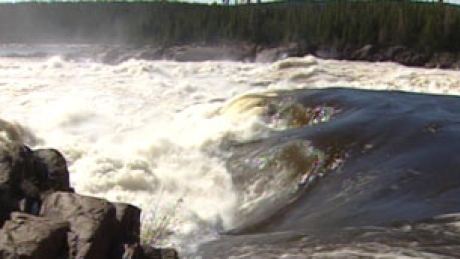
The Churchill River is a river in Newfoundland and Labrador which flows east from the Smallwood Reservoir in Labrador into the Atlantic Ocean via Lake Melville. The river is 856 km (532 mi) long and drains an area of 79,800 km2 (30,800 sq mi); it is the longest river in Atlantic Canada.
Contents
- Map of Churchill River Newfoundland and Labrador Canada
- Hydroelectric projectsEdit
- U BoatEdit
- References
Map of Churchill River, Newfoundland and Labrador, Canada
The river is still known locally as Mishtashipu by the Innu, and as the Grand River by the peoples of NunatuKavut and Nunatsiavut, and Settlers who identify as Labradorians.
In 1821, Captain William Martin, in command of HM brig Clinker, took it upon himself to name the river the Hamilton River after the then Commodore-Governor of Newfoundland, Sir Charles Hamilton. On February 1, 1965, the river was renamed the Churchill River by Premier Joey Smallwood, in honour of former British Prime Minister Winston Churchill.
Hydroelectric projectsEdit
Churchill Falls is the site of a major hydroelectric project, which has a rated capacity of 5,428 MW. Other hydroelectric plants on the river are planned bringing the total to over 9,200 MW. The Churchill Falls development has become a source of friction between two Canadian provinces. The province of Newfoundland and Labrador believes that Hydro-Québec, which provided a major part of the financing and access to the North American power grid, has taken a disproportionate share of the profits from this development. Hydro-Québec buys power from the Churchill Falls project at rates established in 1969.
U BoatEdit
It is believed (although it is pure speculation at this point) that the wreck of a U Boat has been found just downstream of Muskrat Falls.