
Population 2,201 Civil parish Church Lawton Local time Tuesday 12:49 AM | OS grid reference SJ821557 Unitary authority Dialling code 01270 | |
 | ||
Weather 4°C, Wind W at 11 km/h, 94% Humidity | ||
A50 church lawton to arclid front view with rearview mirror
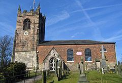
Church Lawton is a small village and located in the unitary authority of Cheshire East and the ceremonial county of Cheshire in England. Its location is such that its eastern boundary forms part of the county boundary between Cheshire and Staffordshire and, because of its close proximity to Stoke-on-Trent, the parish has a Stoke postcode. In addition to ribbon development connecting Kidsgrove (in Staffordshire) with Scholar Green (in Odd Rode parish), the parish also contains the hamlets of Lawton Gate, Lawton Heath and Lawton Heath End, and the Lawton Hall estate. According to the 2001 census, the population of the entire parish was 2,201.
Contents
- A50 church lawton to arclid front view with rearview mirror
- Map of Church Lawton Stoke on Trent UK
- History
- Medieval history
- Governance
- References
Map of Church Lawton, Stoke-on-Trent, UK
History
There is evidence of human activity within the parish stretching back to the Neolithic period: a polished axe was found in the parish that was possibly made in Cornwall.
The collection of Church Lawton Barrows, also known as the Church Lawton Complex, is a significant Bronze Age site in the parish. The Complex consists of three Bronze Age mounds of which only two (Church Lawton II and Church Lawton III) survive. Church Lawton III is the more important of the two, having been excavated in the early 1980s. It seems to have been built in two phases; the first phase consisted of one of the few stone circles found in Cheshire, which was roughly 22.5 metres (73 ft 9 in) in diameter, with a turf and daub platform in the centre, on which dead bodies were probably placed as part of an excarnation ritual prior to burial. There were gaps to the north and south of the circle serving as entrances, with two of the stones standing upright, with the remainder deliberately placed on their side. The second phase covered the central part with sandy subsoil and surrounded it with a low turf wall.
Church Lawton II was also built in two phases. In the first, a low mound made from sand and gravel subsoil surrounded by a ditch was constructed. It was about 16 metres (52 ft) in diameter and 1.5 metres (5 ft) high. In the centre of the mound was a sand-filled boat-shaped hollow with a wooden lid. It was found to be empty of any bones, possibly because any bones had rotted away in the acidic soil environment. Eighteen pits, most likely cremation pits, were found on the mound, and four outside the surrounding ditch. Most of the contents of these were adults, but a few were children or foetuses. Two food vessels and two "Collared Urns" were also found. In the second phase, the diameter increased to 30 metres (98 ft), but there were only a number of fire pits and pyres discovered along with one actual cremation. A number of pottery shards were also recovered, though they had been badly damaged by ploughing. Some pottery associated with the Beaker culture was also recovered from what would have been the soil surface at the time of construction, showing that this area had human habitation for an extended period.
Nothing of substance is known about Church Lawton I, as it was partially destroyed by the building of the current A5011 Newcastle under Lyme to Sandbach road some time before 1881. The remaining part of it was subsequently destroyed by the building of a petrol station, much later.
Medieval history
In 1338 Ralph de Lawton, who held the manor of Bog-lawton (now Church Lawton) surrendered it to Henry de Motlowe and his heirs. Henry, whose family came from Nether Alderley, later became Lord Chief Justice of Ireland.
Governance
Church Lawton is an ancient parish, though there is some evidence that it began by being part of the ancient parish of Astbury (now Newbold Astbury.). It also was part of Nantwich Hundred, Congleton Poor Law Union, Rural Sanitary District, and after 1866 it formed part of Congleton Rural District. County boundary changes in 1965 led to an exchange of small pieces of land between it and the civil parish of Kidsgrove, in Kidsgrove Urban District, in the neighbouring county of Staffordshire. From 1974 the civil parish was served by Congleton Borough Council, which was succeeded on 1 April 2009 by the new unitary authority of Cheshire East .
In terms of parliamentary representation, Church Lawton was in the Cheshire Southern Division from 1832 to 1867; in the Cheshire Mid Division, from 1867 to 1885; in the Crewe Division, from 1885 to 1948; and from 1948 it was in Knutsford County Constituency, but it is currently in Congleton County Constituency.