
Local time Sunday 10:32 PM | Population (approx.) 1,135 | |
 | ||
Weather 3°C, Wind SW at 5 km/h, 93% Humidity | ||
Chochołów [xɔˈxɔwuf] is a village in the administrative district of Gmina Czarny Dunajec, within Nowy Targ County, Lesser Poland Voivodeship, in southern Poland, close to the border with Slovakia.
Contents
Map of Chocho%C5%82%C3%B3w, Poland
Chochołów lies approximately 9 kilometres (6 mi) south of Czarny Dunajec, 19 km (12 mi) south-west of Nowy Targ, and 78 km (48 mi) south of the regional capital Kraków. The village has an approximate population of 1,135.
History
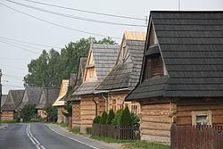
Chochołów is a village comprised almost exclusively of the heritage Polish wooden houses (góralskie chaty) built by the Góral highlanders. It became known as the place of Chochołów Uprising of 1846 (Powstanie chochołowskie) against the foreign oppression throughout the nineteenth century Austrian Partition of Poland.
Its economy is closely associated with the popular Polish-Slovak border crossing.