
Length 51 km | Source elevation 70 m | |
 | ||
Main source Mount Gretna Heights, Pennsylvania1,100 feet (340 m) Basin size 126 square miles (330 km) Bridges Seigrist's Mill Covered Bridge | ||
Chiques Creek (known as Chickies Creek until 2002) is a 31.6-mile-long (50.9 km) tributary of the Susquehanna River in Lebanon and Lancaster counties, Pennsylvania in the United States.
Contents
- Map of Chiques Creek Pennsylvania USA
- NameEdit
- Course and watershedEdit
- Covered bridgesEdit
- TributariesEdit
- References
Map of Chiques Creek, Pennsylvania, USA
The source is at an elevation of 1,100 feet (340 m) near Mount Gretna Heights in Lebanon County. The mouth is the confluence with the Susquehanna River at an elevation of 230 feet (70 m) at Marietta in Lancaster County.
NameEdit
The name of the creek (Chiquesalunga) comes from the Susquehannock or Conestoga Indian term Ka'ot'sch'ie'ra, which means "Place-crayfish." The surrounding area, including Chiques Creek and the large rock wall or promontory that overlooks the Susquehanna River (called "Chickies Rock" at Chickies Rock County Park), between modern Marietta and Columbia, Lancaster County, Pennsylvania, was called Ka'ot'sch'ie'ra by the native people (or, to the English, "Chiquesalunga"). The word "Conestoga" comes from the native term Gan'ochs'a'go'jat'ga, which means "roof." As such, it was their word for "town." The Len'api would later call the area Scha'hamu'is'ing or "Crawfish-place."
The United States Geological Survey Board on Geographic Names has made three official decisions on the name of the creek, deciding it was Chickies Creek in 1896 and 1916 before changing it to Chiques Creek in 2002. The USGS Geographic Names Information System recognizes the following thirteen variant names for the creek: Big Chickies Creek, Big Chiques Creek, Big Chiquesalunga Creek, Chickesalapga Creek, Chickeswalungo Creek, Chickies Creek, Chickisalungo Creek, Chicques Creek, Chikiswalunga Creek, Chikiswalungo Creek, Chiquasatunga Creek, Chiquesatonga Creek, and Chiquesatunga Creek.
Course and watershedEdit
Chiques Creek flows generally south for its entire course. The Chickies Creek watershed has a total area of 126 square miles (330 km2) and is part of the larger Chesapeake Bay drainage basin. Chiques Creek's major tributary is Little Chiques Creek, entering roughly one mile upstream its mouth. (hence the variant names with Big in them for the main creek).
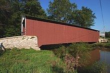
Covered bridgesEdit
Five covered bridges cross the creek in Lancaster County: