
Topo map NTS 92J/10 Prominence 540 m | Age of rock 26.8 ± 1.4 Ma Elevation 2,390 m Parent range Pacific Ranges | |
 | ||
Volcanic arc/belt Pemberton Volcanic BeltCanadian Cascade Arc Similar Coquihalla Mountain, Ring Mountain, The Table, Mount Brew, Mount Cayley | ||
Caleta de fuste fuerteventura december 2015 chipmunk mountain to the beach bar
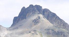
Chipmunk Mountain is a mountain in southwestern British Columbia, Canada, located 23 km (14 mi) southwest of Bralorne. It has an elevation of 2,390 m (7,840 ft) and a topographic prominence of 540 m (1,770 ft), making it the highest point on an east-trending screed ridge. This horn-like rocky tower is similar to The Black Tusk in Garibaldi Provincial Park.
Contents
- Caleta de fuste fuerteventura december 2015 chipmunk mountain to the beach bar
- Map of Chipmunk Mountain Squamish Lillooet C BC Canada
- Chipmunk mountain bc sept 4 2011
- GeologyEdit
- References
Map of Chipmunk Mountain, Squamish-Lillooet C, BC, Canada
The mountain was named in 1920 by James Landsborough after a summit party had given lunch scraps to a chipmunk.
Chipmunk mountain bc sept 4 2011
GeologyEdit
Technically, Chipmunk Mountain is the remains of an extinct volcano that formed during the Miocene epoch. The volcanic rocks comprising Chipmunk Mountain crop out in a 12 km2 (4.6 sq mi) area and consist of pyroclastic rocks, sills and dikes. These volcanic rocks range from basalts to rhyolites, with the majority classifying as basaltic andesites and andesites. They are closely related to the calc-alkaline volcanic centres of the Pemberton Volcanic Belt, indicating that the volcanic rocks comprising Chipmunk Mountain were created as a result of volcanism in the Canadian Cascade Arc. The volcanic rocks have been dated to be 26.8 ± 1.4 million years old, which correlates with the time of Pemberton Belt volcanism.