
- right Stung Tang Krasaing - elevation 16 ft (5 m) Basin area 4,504 km² Mouth Tonlé Sap | - elevation 1,647 ft (502 m) Length 264 km Basin area 4,504 km² | |
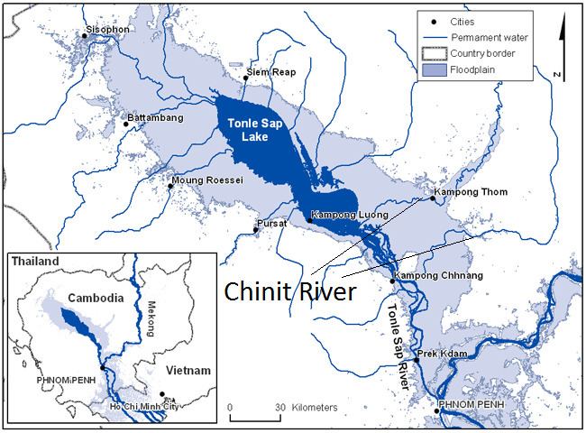 | ||
Chinit River (alternates: Stung Chinit or Stoeng Chinith) is a river of Cambodia. Located in Kampong Thom Province, it is a major tributary of the Tonlé Sap Lake ("Great Lake"), which joins the Tonlé Sap River at the downstream end in the larger Mekong basin. Somewhat unusually the river is looped back into the same river system, which accounts for its length of 264 kilometres (164 mi), leaving Tonlé Sap lake and entering its river again downstream. The prehistoric archaeological site of Samrong Sen is located on the river bank. Water resource projects, commencing in 1971 and in 2003, have had various measures of success. The river is an important trade route.
Contents
Geography
Chinit River, also called Stung Chinit River, is major tributary of the Tonlé Sap River, which flows down from the great lake of the same name from the northeast direction at 12°31′38″N 104°27′31″E, in central Cambodia. It reenters the Tonlé Sap system in the river at 13°32′N 105°47′E. The river's length is approximately 264 kilometres (164 mi) and loops out and into the Tonlé Sap rsystem. Its width varies in the range of 60–90 metres (200–300 ft) over a total river stretch of 110 kilometres (68 mi).
The river drains a catchment area of 5,649 km2 (2,181 sq mi) including the catchment of 1,145 km2 (442 sq mi) of its tributary, the Stung Tang Krasaing, up to its outflow into Tonlé Sap Lake. The river passes through the Bolaven Plateau of Laos, reaches its highest elevation point, 288 metres (945 ft), at Phumi Chrach, and ends at its outflow point on Tonlé Sap Lake at an elevation of 5 metres (16 ft).There are gentler slopes noted towards the downstream. Its main lake is Bung Real Lake.
The main city along the river is Santuk District Capital. Samrong Sen, a prehistoric archaeological site of Neolithic Age is located on its right bank.
Climate
According to the data sourced to the Hydrologic Water Year Book of Mekong Committee, the basin's climatic parameters recorded at the Kampong Thmar station, are; an average annual temperature of 27.8 °C (82.0 °F) with a minimum of 26.2 °C (79.2 °F) in December and maximum of 29.8 °C (85.6 °F) in March. The average annual evaporation rate is 1,455 millimetres (57.3 in) with a standard deviation of 133 millimetres (5.2 in) per month. The average annual precipitation recorded is 1,590 millimetres (63 in) with heavy rains recorded from April to October. The records of the Agrometerological Group of FAO of Research and Technology Development Division show the sunshine hours as 7.3 hours per day and the solar radiation at an annual average of 19.5 MJ/m2 per day.
Navigation
Inland navigation is practiced to a very limited extent due to shallow draft. Fishing and community boats are plied by villagers who reside on the banks of the river, for fishing and to transport goods to the markets.
Land use
The Chinit River basin land use distribution is 75.5% under forest cover, 14.8% under paddy cultivation and the balance area is under other agricultural uses. Agricultural farming, mostly during the wet season of rice cultivation (seasonal rice and floating rice) is the major economic activity of the people living in the valley. Rice is also grown during the non-rainy season, but its acreage is limited to 10% of the cultivated area. White corn, green beans and tobacco are also grown in the higher elevations of the valley.
Aquafauna
The Chinit River has been a subject of studies on fish migration. Movement of fish has been studied on Chinit and also on other rivers in the Mekong through sampling techniques carried out in 20-to-50-kilometre (12 to 31 mi) stretches upstream of the flooded areas, to identify larval and fry fish in five tributaries. Seventy-one species belonging to 17 families have been recorded in the Chinit River. It was also noted during these studies that the species recorded were distinctive for each tributary but the fish fauna found in Chinit and Stung tributaries were identical.