
Length 80 km Mouth elevation 0 | Source Chilkat Glacier Country United States of America | |
 | ||
- location 1 mile (1.6 km) southwest of Haines, St. Elias Mountains | ||
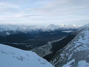
Chilkat valley upper chilkat river
The Chilkat River is a river in British Columbia and southeastern Alaska that flows southward from the Coast Range to the Chilkat Inlet and ultimately Lynn Canal. It is about 80 kilometres (50 mi) long. It begins at Chilkat Glacier, in Alaska, flows west and south in British Columbia for 27 kilometres (17 mi), enters Alaska and continues southwest for another 60 kilometres (37 mi). It reaches the ocean at the abandoned area of Wells, Alaska and deposits into a long delta area.
Contents
Map of Chilkat River, Alaska, USA
The river was named by the Russians for the Chilkat group of Tlingit, called /Ǯiɬqut/ in their own language, who lived in the region. The name means "salmon storehouse".
Near the Chilkat River is the Alaska Chilkat Bald Eagle Preserve, where thousands of bald eagles appear between October and February, to take advantage of late salmon runs. Nearby Haines, the nearest town, is the most common organization spot for birdwatchers.